You are here: Home > Network List > TA - USArray Transportable Network (new EarthScope stations) Stations List
> Station 121A Cookes Peak, Deming, NM, USA > Earthquake Result Viewer
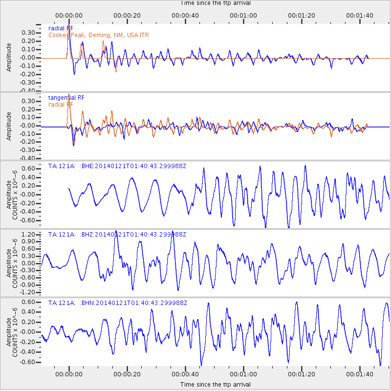
121A Cookes Peak, Deming, NM, USA - Earthquake Result Viewer
*The percent match for this event was below the threshold and hence no stack was calculated.
| Earthquake location: |
Tonga Islands |
| Earthquake latitude/longitude: |
-15.1/-174.7 |
| Earthquake time(UTC): |
2014/01/21 (021) 01:29:07 GMT |
| Earthquake Depth: |
6.1 km |
| Earthquake Magnitude: |
6.1 MWW, 6.1 MWB, 6.2 MWC, 6.5 MI |
| Earthquake Catalog/Contributor: |
NEIC PDE/NEIC COMCAT |
|
| Network: |
TA USArray Transportable Network (new EarthScope stations) |
| Station: |
121A Cookes Peak, Deming, NM, USA |
| Lat/Lon: |
32.53 N/107.79 W |
| Elevation: |
1652 m |
|
| Distance: |
79.6 deg |
| Az: |
52.189 deg |
| Baz: |
244.582 deg |
| Ray Param: |
$rayparam |
*The percent match for this event was below the threshold and hence was not used in the summary stack. |
|
| Radial Match: |
79.12374 % |
| Radial Bump: |
400 |
| Transverse Match: |
61.204327 % |
| Transverse Bump: |
400 |
| SOD ConfigId: |
626651 |
| Insert Time: |
2014-04-20 10:37:30.558 +0000 |
| GWidth: |
2.5 |
| Max Bumps: |
400 |
| Tol: |
0.001 |
|
Signal To Noise
| Channel | StoN | STA | LTA |
| TA:121A: :BHZ:20140121T01:40:43.299988Z | 1.8662686 | 4.2207077E-7 | 2.2615755E-7 |
| TA:121A: :BHN:20140121T01:40:43.299988Z | 0.67573667 | 8.976937E-8 | 1.3284668E-7 |
| TA:121A: :BHE:20140121T01:40:43.299988Z | 1.4925228 | 3.0168792E-7 | 2.0213285E-7 |
| Arrivals |
| Ps | |
| PpPs | |
| PsPs/PpSs | |


