You are here: Home > Network List > TA - USArray Transportable Network (new EarthScope stations) Stations List
> Station O48A Farmland, IN, USA > Earthquake Result Viewer
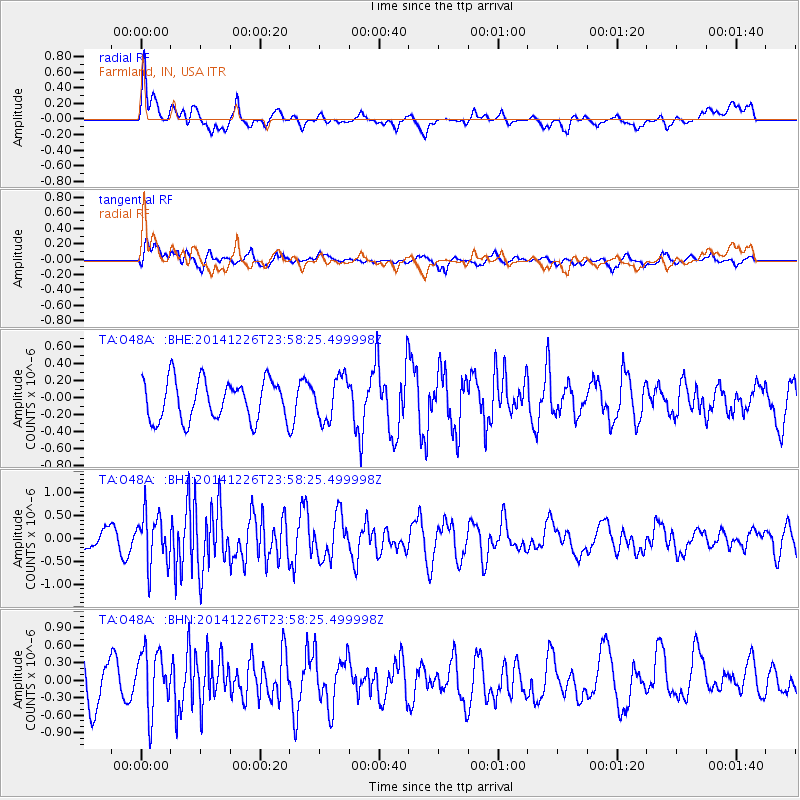
O48A Farmland, IN, USA - Earthquake Result Viewer
*The percent match for this event was below the threshold and hence no stack was calculated.
| Earthquake location: |
South Of Panama |
| Earthquake latitude/longitude: |
6.5/-82.3 |
| Earthquake time(UTC): |
2014/12/26 (360) 23:52:14 GMT |
| Earthquake Depth: |
10 km |
| Earthquake Magnitude: |
5.5 MB |
| Earthquake Catalog/Contributor: |
NEIC PDE/NEIC COMCAT |
|
| Network: |
TA USArray Transportable Network (new EarthScope stations) |
| Station: |
O48A Farmland, IN, USA |
| Lat/Lon: |
40.26 N/85.16 W |
| Elevation: |
300 m |
|
| Distance: |
33.7 deg |
| Az: |
356.123 deg |
| Baz: |
174.963 deg |
| Ray Param: |
$rayparam |
*The percent match for this event was below the threshold and hence was not used in the summary stack. |
|
| Radial Match: |
71.24219 % |
| Radial Bump: |
400 |
| Transverse Match: |
52.44224 % |
| Transverse Bump: |
400 |
| SOD ConfigId: |
3390531 |
| Insert Time: |
2019-04-15 19:28:47.450 +0000 |
| GWidth: |
2.5 |
| Max Bumps: |
400 |
| Tol: |
0.001 |
|
Signal To Noise
| Channel | StoN | STA | LTA |
| TA:O48A: :BHZ:20141226T23:58:25.499998Z | 3.6220253 | 5.4870776E-7 | 1.5149197E-7 |
| TA:O48A: :BHN:20141226T23:58:25.499998Z | 1.6375489 | 5.205719E-7 | 3.1789702E-7 |
| TA:O48A: :BHE:20141226T23:58:25.499998Z | 1.0641499 | 2.4795935E-7 | 2.3301169E-7 |
| Arrivals |
| Ps | |
| PpPs | |
| PsPs/PpSs | |


