You are here: Home > Network List > AV - Alaska Volcano Observatory Stations List
> Station AKRB Akutan Reef Bight, Akutan Volcano, Alaska > Earthquake Result Viewer
AKRB Akutan Reef Bight, Akutan Volcano, Alaska - Earthquake Result Viewer
| Earthquake location: |
Flores Sea |
| Earthquake latitude/longitude: |
-7.1/120.3 |
| Earthquake time(UTC): |
2014/01/23 (023) 00:52:15 GMT |
| Earthquake Depth: |
579 km |
| Earthquake Magnitude: |
5.5 MWB, 5.5 MWC |
| Earthquake Catalog/Contributor: |
NEIC PDE/NEIC COMCAT |
|
| Network: |
AV Alaska Volcano Observatory |
| Station: |
AKRB Akutan Reef Bight, Akutan Volcano, Alaska |
| Lat/Lon: |
54.13 N/166.07 W |
| Elevation: |
334 m |
|
| Distance: |
86.2 deg |
| Az: |
34.462 deg |
| Baz: |
252.585 deg |
| Ray Param: |
0.042520497 |
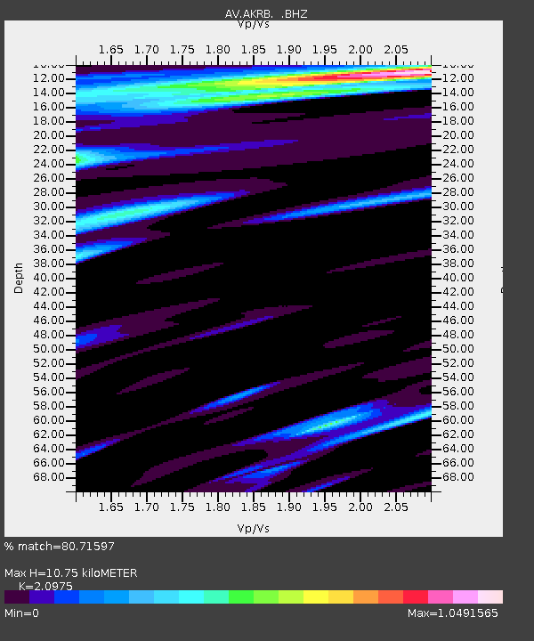
| Estimated Moho Depth: |
10.75 km |
| Estimated Crust Vp/Vs: |
2.10 |
| Assumed Crust Vp: |
5.989 km/s |
| Estimated Crust Vs: |
2.855 km/s |
| Estimated Crust Poisson's Ratio: |
0.35 |
|
| Radial Match: |
80.71597 % |
| Radial Bump: |
400 |
| Transverse Match: |
56.15377 % |
| Transverse Bump: |
400 |
| SOD ConfigId: |
626651 |
| Insert Time: |
2014-04-20 11:10:43.391 +0000 |
| GWidth: |
2.5 |
| Max Bumps: |
400 |
| Tol: |
0.001 |
|

Signal To Noise
| Channel | StoN | STA | LTA |
| AV:AKRB: :BHZ:20140123T01:03:25.020012Z | 2.4922652 | 1.4895529E-5 | 5.9767026E-6 |
| AV:AKRB: :BHN:20140123T01:03:25.020012Z | 1.3666655 | 9.6663225E-6 | 7.072925E-6 |
| AV:AKRB: :BHE:20140123T01:03:25.020012Z | 2.6854687 | 1.1687827E-5 | 4.352248E-6 |
| Arrivals |
| Ps | 2.0 SECOND |
| PpPs | 5.5 SECOND |
| PsPs/PpSs | 7.5 SECOND |


