You are here: Home > Network List > TA - USArray Transportable Network (new EarthScope stations) Stations List
> Station G59A Clarenceville, QC, USA > Earthquake Result Viewer
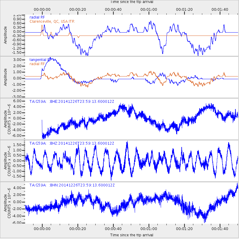
G59A Clarenceville, QC, USA - Earthquake Result Viewer
*The percent match for this event was below the threshold and hence no stack was calculated.
| Earthquake location: |
South Of Panama |
| Earthquake latitude/longitude: |
8.0/-82.3 |
| Earthquake time(UTC): |
2014/12/26 (360) 23:52:30 GMT |
| Earthquake Depth: |
35 km |
| Earthquake Magnitude: |
6.0 MW, 6.1 ML |
| Earthquake Catalog/Contributor: |
ISC/ISC |
|
| Network: |
TA USArray Transportable Network (new EarthScope stations) |
| Station: |
G59A Clarenceville, QC, USA |
| Lat/Lon: |
45.08 N/73.18 W |
| Elevation: |
36 m |
|
| Distance: |
37.8 deg |
| Az: |
10.542 deg |
| Baz: |
194.819 deg |
| Ray Param: |
$rayparam |
*The percent match for this event was below the threshold and hence was not used in the summary stack. |
|
| Radial Match: |
18.597908 % |
| Radial Bump: |
400 |
| Transverse Match: |
37.09427 % |
| Transverse Bump: |
400 |
| SOD ConfigId: |
3390531 |
| Insert Time: |
2019-04-15 19:37:17.377 +0000 |
| GWidth: |
2.5 |
| Max Bumps: |
400 |
| Tol: |
0.001 |
|
Signal To Noise
| Channel | StoN | STA | LTA |
| TA:G59A: :BHZ:20141226T23:59:13.600012Z | 1.3627988 | 5.990508E-7 | 4.395739E-7 |
| TA:G59A: :BHN:20141226T23:59:13.600012Z | 0.92888016 | 5.3870863E-6 | 5.7995494E-6 |
| TA:G59A: :BHE:20141226T23:59:13.600012Z | 1.8536446 | 3.1553554E-6 | 1.702244E-6 |
| Arrivals |
| Ps | |
| PpPs | |
| PsPs/PpSs | |


