You are here: Home > Network List > TA - USArray Transportable Network (new EarthScope stations) Stations List
> Station H17A Grant Village (NPS), Yellowstone Nt. Park, WY, USA > Earthquake Result Viewer
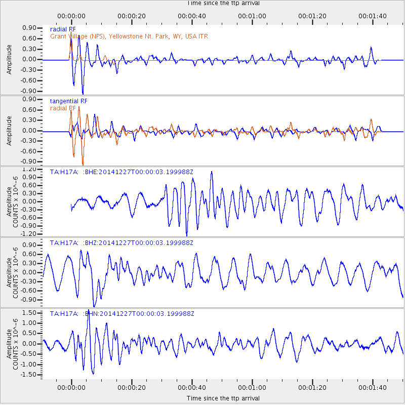
H17A Grant Village (NPS), Yellowstone Nt. Park, WY, USA - Earthquake Result Viewer
*The percent match for this event was below the threshold and hence no stack was calculated.
| Earthquake location: |
South Of Panama |
| Earthquake latitude/longitude: |
8.0/-82.3 |
| Earthquake time(UTC): |
2014/12/26 (360) 23:52:30 GMT |
| Earthquake Depth: |
35 km |
| Earthquake Magnitude: |
6.0 MW, 6.1 ML |
| Earthquake Catalog/Contributor: |
ISC/ISC |
|
| Network: |
TA USArray Transportable Network (new EarthScope stations) |
| Station: |
H17A Grant Village (NPS), Yellowstone Nt. Park, WY, USA |
| Lat/Lon: |
44.40 N/110.58 W |
| Elevation: |
2400 m |
|
| Distance: |
43.8 deg |
| Az: |
330.636 deg |
| Baz: |
137.35 deg |
| Ray Param: |
$rayparam |
*The percent match for this event was below the threshold and hence was not used in the summary stack. |
|
| Radial Match: |
74.309494 % |
| Radial Bump: |
400 |
| Transverse Match: |
72.24432 % |
| Transverse Bump: |
400 |
| SOD ConfigId: |
3390531 |
| Insert Time: |
2019-04-15 19:37:18.778 +0000 |
| GWidth: |
2.5 |
| Max Bumps: |
400 |
| Tol: |
0.001 |
|
Signal To Noise
| Channel | StoN | STA | LTA |
| TA:H17A: :BHZ:20141227T00:00:03.199988Z | 1.4478797 | 4.626829E-7 | 3.1955892E-7 |
| TA:H17A: :BHN:20141227T00:00:03.199988Z | 3.7088642 | 5.0359176E-7 | 1.357806E-7 |
| TA:H17A: :BHE:20141227T00:00:03.199988Z | 2.3481438 | 4.6365952E-7 | 1.9745788E-7 |
| Arrivals |
| Ps | |
| PpPs | |
| PsPs/PpSs | |


