You are here: Home > Network List > CB - China National Seismic Network Stations List
> Station GZH Guangzhou,Guangdong Province > Earthquake Result Viewer
GZH Guangzhou,Guangdong Province - Earthquake Result Viewer
| Earthquake location: |
Java, Indonesia |
| Earthquake latitude/longitude: |
-8.0/109.3 |
| Earthquake time(UTC): |
2014/01/25 (025) 05:14:18 GMT |
| Earthquake Depth: |
66 km |
| Earthquake Magnitude: |
6.1 MWW, 6.1 MWC, 6.2 MWC, 6.2 MWB |
| Earthquake Catalog/Contributor: |
NEIC PDE/NEIC COMCAT |
|
| Network: |
CB China National Seismic Network |
| Station: |
GZH Guangzhou,Guangdong Province |
| Lat/Lon: |
23.65 N/113.65 E |
| Elevation: |
65 m |
|
| Distance: |
31.7 deg |
| Az: |
7.664 deg |
| Baz: |
188.282 deg |
| Ray Param: |
0.07879708 |
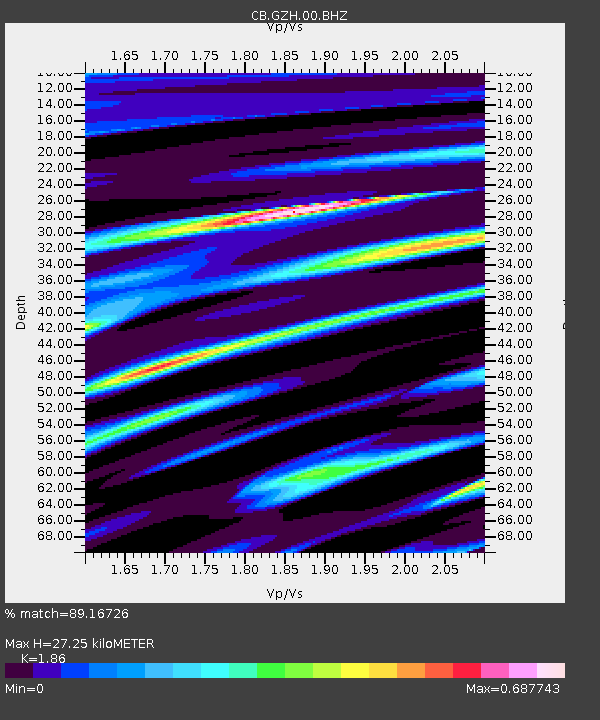
| Estimated Moho Depth: |
27.25 km |
| Estimated Crust Vp/Vs: |
1.86 |
| Assumed Crust Vp: |
6.276 km/s |
| Estimated Crust Vs: |
3.374 km/s |
| Estimated Crust Poisson's Ratio: |
0.30 |
|
| Radial Match: |
89.16726 % |
| Radial Bump: |
228 |
| Transverse Match: |
67.164215 % |
| Transverse Bump: |
400 |
| SOD ConfigId: |
626651 |
| Insert Time: |
2014-04-20 11:45:35.732 +0000 |
| GWidth: |
2.5 |
| Max Bumps: |
400 |
| Tol: |
0.001 |
|

Signal To Noise
| Channel | StoN | STA | LTA |
| CB:GZH:00:BHZ:20140125T05:20:05.950002Z | 5.1465707 | 1.2978244E-6 | 2.5217267E-7 |
| CB:GZH:00:BHN:20140125T05:20:05.950002Z | 4.9373374 | 8.3590186E-7 | 1.6930217E-7 |
| CB:GZH:00:BHE:20140125T05:20:05.950002Z | 1.0672321 | 1.5622938E-7 | 1.4638745E-7 |
| Arrivals |
| Ps | 4.0 SECOND |
| PpPs | 12 SECOND |
| PsPs/PpSs | 16 SECOND |


