You are here: Home > Network List > II - Global Seismograph Network (GSN - IRIS/IDA) Stations List
> Station KIV Kislovodsk, Russia > Earthquake Result Viewer
KIV Kislovodsk, Russia - Earthquake Result Viewer

| Earthquake location: |
Kuril Islands |
| Earthquake latitude/longitude: |
43.3/146.7 |
| Earthquake time(UTC): |
1995/01/21 (021) 08:47:29 GMT |
| Earthquake Depth: |
63 km |
| Earthquake Magnitude: |
6.5 MB, 6.6 UNKNOWN, 6.4 MW |
| Earthquake Catalog/Contributor: |
WHDF/NEIC |
|
| Network: |
II Global Seismograph Network (GSN - IRIS/IDA) |
| Station: |
KIV Kislovodsk, Russia |
| Lat/Lon: |
43.96 N/42.69 E |
| Elevation: |
1054 m |
|
| Distance: |
69.8 deg |
| Az: |
311.707 deg |
| Baz: |
48.96 deg |
| Ray Param: |
0.05526384 |
| Estimated Moho Depth: |
20.25 km |
| Estimated Crust Vp/Vs: |
1.80 |
| Assumed Crust Vp: |
6.247 km/s |
| Estimated Crust Vs: |
3.465 km/s |
| Estimated Crust Poisson's Ratio: |
0.28 |
|
| Radial Match: |
98.58535 % |
| Radial Bump: |
315 |
| Transverse Match: |
97.21863 % |
| Transverse Bump: |
400 |
| SOD ConfigId: |
6273 |
| Insert Time: |
2010-03-01 18:31:54.506 +0000 |
| GWidth: |
2.5 |
| Max Bumps: |
400 |
| Tol: |
0.001 |
|
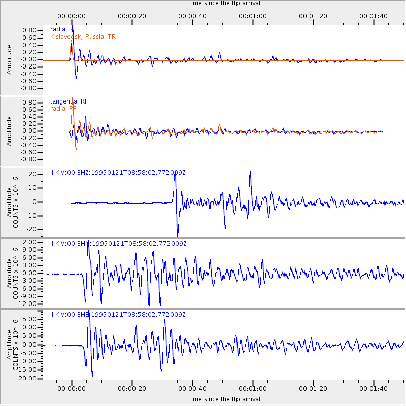
Signal To Noise
| Channel | StoN | STA | LTA |
| II:KIV:00:BHN:19950121T08:58:02.772009Z | 39.48411 | 3.282263E-6 | 8.31287E-8 |
| II:KIV:00:BHE:19950121T08:58:02.772009Z | 31.42371 | 3.4150883E-6 | 1.08678705E-7 |
| II:KIV:00:BHZ:19950121T08:58:02.772009Z | 65.385124 | 7.2787266E-6 | 1.1132083E-7 |
| Arrivals |
| Ps | 2.7 SECOND |
| PpPs | 8.8 SECOND |
| PsPs/PpSs | 11 SECOND |


