You are here: Home > Network List > UW - Pacific Northwest Regional Seismic Network Stations List
> Station UMAT Pilot Rock, OR, USA > Earthquake Result Viewer
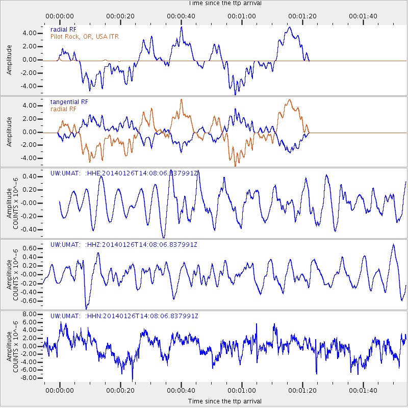
UMAT Pilot Rock, OR, USA - Earthquake Result Viewer
*The percent match for this event was below the threshold and hence no stack was calculated.
| Earthquake location: |
Greece |
| Earthquake latitude/longitude: |
38.2/20.5 |
| Earthquake time(UTC): |
2014/01/26 (026) 13:55:42 GMT |
| Earthquake Depth: |
8.0 km |
| Earthquake Magnitude: |
6.1 MWW, 6.1 MWB, 6.2 MWC |
| Earthquake Catalog/Contributor: |
NEIC PDE/NEIC COMCAT |
|
| Network: |
UW Pacific Northwest Regional Seismic Network |
| Station: |
UMAT Pilot Rock, OR, USA |
| Lat/Lon: |
45.29 N/118.96 W |
| Elevation: |
1318 m |
|
| Distance: |
89.2 deg |
| Az: |
332.657 deg |
| Baz: |
30.836 deg |
| Ray Param: |
$rayparam |
*The percent match for this event was below the threshold and hence was not used in the summary stack. |
|
| Radial Match: |
62.712856 % |
| Radial Bump: |
400 |
| Transverse Match: |
61.568203 % |
| Transverse Bump: |
400 |
| SOD ConfigId: |
626651 |
| Insert Time: |
2014-04-20 12:15:21.559 +0000 |
| GWidth: |
2.5 |
| Max Bumps: |
400 |
| Tol: |
0.001 |
|
Signal To Noise
| Channel | StoN | STA | LTA |
| UW:UMAT: :HHZ:20140126T14:08:06.837991Z | 0.56498253 | 1.3852562E-7 | 2.4518567E-7 |
| UW:UMAT: :HHN:20140126T14:08:06.837991Z | 1.3896852 | 4.482558E-6 | 3.2255923E-6 |
| UW:UMAT: :HHE:20140126T14:08:06.837991Z | 1.5705549 | 2.9295887E-7 | 1.8653208E-7 |
| Arrivals |
| Ps | |
| PpPs | |
| PsPs/PpSs | |


