You are here: Home > Network List > TA - USArray Transportable Network (new EarthScope stations) Stations List
> Station J01E Myrtle Point, OR, USA > Earthquake Result Viewer
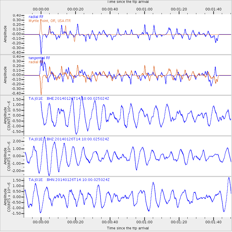
J01E Myrtle Point, OR, USA - Earthquake Result Viewer
*The percent match for this event was below the threshold and hence no stack was calculated.
| Earthquake location: |
Greece |
| Earthquake latitude/longitude: |
38.3/20.6 |
| Earthquake time(UTC): |
2014/01/26 (026) 13:57:19 GMT |
| Earthquake Depth: |
10 km |
| Earthquake Magnitude: |
5.6 MB |
| Earthquake Catalog/Contributor: |
NEIC PDE/NEIC COMCAT |
|
| Network: |
TA USArray Transportable Network (new EarthScope stations) |
| Station: |
J01E Myrtle Point, OR, USA |
| Lat/Lon: |
43.16 N/123.93 W |
| Elevation: |
128 m |
|
| Distance: |
92.8 deg |
| Az: |
334.821 deg |
| Baz: |
27.228 deg |
| Ray Param: |
$rayparam |
*The percent match for this event was below the threshold and hence was not used in the summary stack. |
|
| Radial Match: |
56.70983 % |
| Radial Bump: |
400 |
| Transverse Match: |
66.08748 % |
| Transverse Bump: |
400 |
| SOD ConfigId: |
626651 |
| Insert Time: |
2014-04-20 12:31:09.663 +0000 |
| GWidth: |
2.5 |
| Max Bumps: |
400 |
| Tol: |
0.001 |
|
Signal To Noise
| Channel | StoN | STA | LTA |
| TA:J01E: :BHZ:20140126T14:10:00.025024Z | 3.4072201 | 1.805534E-6 | 5.299141E-7 |
| TA:J01E: :BHN:20140126T14:10:00.025024Z | 2.1038063 | 8.007492E-7 | 3.8061927E-7 |
| TA:J01E: :BHE:20140126T14:10:00.025024Z | 1.0518985 | 9.249229E-7 | 8.7928913E-7 |
| Arrivals |
| Ps | |
| PpPs | |
| PsPs/PpSs | |


