You are here: Home > Network List > AZ - ANZA Regional Network Stations List
> Station SMER AZ.SMER > Earthquake Result Viewer
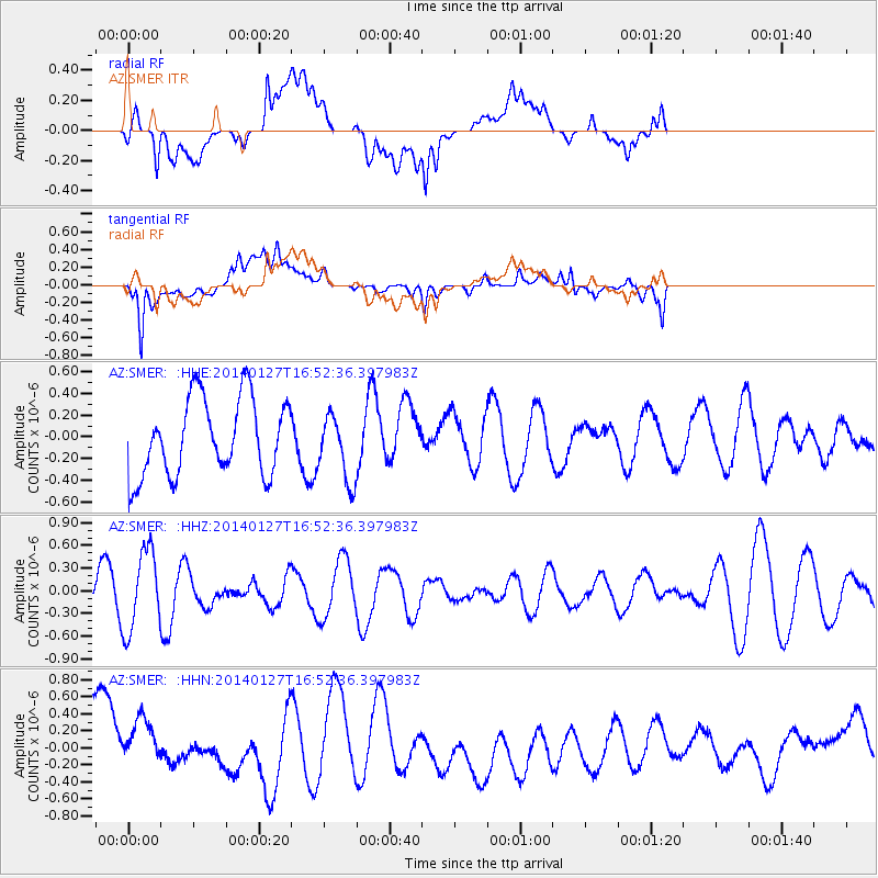
SMER AZ.SMER - Earthquake Result Viewer
*The percent match for this event was below the threshold and hence no stack was calculated.
| Earthquake location: |
Southern Bolivia |
| Earthquake latitude/longitude: |
-19.3/-63.9 |
| Earthquake time(UTC): |
2014/01/27 (027) 16:42:37 GMT |
| Earthquake Depth: |
600 km |
| Earthquake Magnitude: |
5.6 MWB |
| Earthquake Catalog/Contributor: |
NEIC PDE/NEIC COMCAT |
|
| Network: |
AZ ANZA Regional Network |
| Station: |
SMER AZ.SMER |
| Lat/Lon: |
33.46 N/117.17 W |
| Elevation: |
355 m |
|
| Distance: |
73.0 deg |
| Az: |
315.532 deg |
| Baz: |
127.662 deg |
| Ray Param: |
$rayparam |
*The percent match for this event was below the threshold and hence was not used in the summary stack. |
|
| Radial Match: |
69.794235 % |
| Radial Bump: |
400 |
| Transverse Match: |
67.28432 % |
| Transverse Bump: |
400 |
| SOD ConfigId: |
626651 |
| Insert Time: |
2014-04-20 12:39:24.448 +0000 |
| GWidth: |
2.5 |
| Max Bumps: |
400 |
| Tol: |
0.001 |
|
Signal To Noise
| Channel | StoN | STA | LTA |
| AZ:SMER: :HHZ:20140127T16:52:36.397983Z | 1.3960468 | 5.286283E-7 | 3.7866084E-7 |
| AZ:SMER: :HHN:20140127T16:52:36.397983Z | 0.93692726 | 3.8348244E-7 | 4.0929797E-7 |
| AZ:SMER: :HHE:20140127T16:52:36.397983Z | 0.84805125 | 3.0051498E-7 | 3.5435943E-7 |
| Arrivals |
| Ps | |
| PpPs | |
| PsPs/PpSs | |


