You are here: Home > Network List > IU - Global Seismograph Network (GSN - IRIS/USGS) Stations List
> Station CCM Cathedral Cave, Missouri, USA > Earthquake Result Viewer
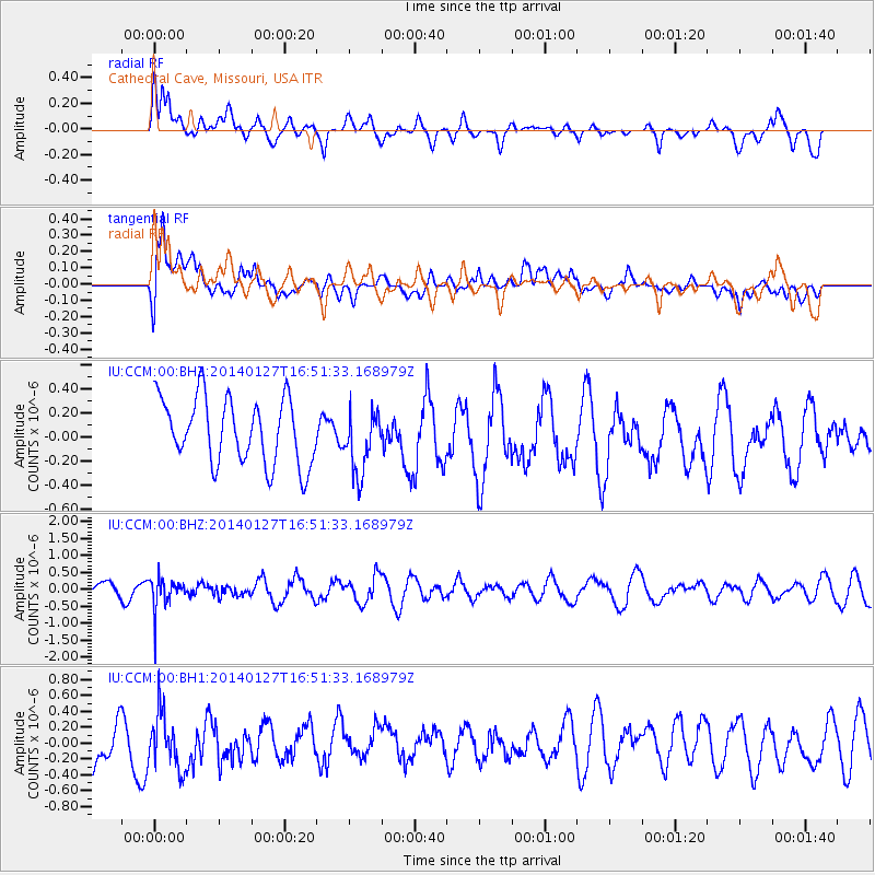
CCM Cathedral Cave, Missouri, USA - Earthquake Result Viewer
*The percent match for this event was below the threshold and hence no stack was calculated.
| Earthquake location: |
Southern Bolivia |
| Earthquake latitude/longitude: |
-19.3/-63.9 |
| Earthquake time(UTC): |
2014/01/27 (027) 16:42:37 GMT |
| Earthquake Depth: |
600 km |
| Earthquake Magnitude: |
5.6 MWB |
| Earthquake Catalog/Contributor: |
NEIC PDE/NEIC COMCAT |
|
| Network: |
IU Global Seismograph Network (GSN - IRIS/USGS) |
| Station: |
CCM Cathedral Cave, Missouri, USA |
| Lat/Lon: |
38.06 N/91.24 W |
| Elevation: |
222 m |
|
| Distance: |
62.5 deg |
| Az: |
335.894 deg |
| Baz: |
150.739 deg |
| Ray Param: |
$rayparam |
*The percent match for this event was below the threshold and hence was not used in the summary stack. |
|
| Radial Match: |
48.57071 % |
| Radial Bump: |
400 |
| Transverse Match: |
45.424767 % |
| Transverse Bump: |
400 |
| SOD ConfigId: |
626651 |
| Insert Time: |
2014-04-20 12:44:43.663 +0000 |
| GWidth: |
2.5 |
| Max Bumps: |
400 |
| Tol: |
0.001 |
|
Signal To Noise
| Channel | StoN | STA | LTA |
| IU:CCM:00:BHZ:20140127T16:51:33.168979Z | 1.6987728 | 4.752117E-7 | 2.7973823E-7 |
| IU:CCM:00:BH1:20140127T16:51:33.168979Z | 1.2059181 | 3.5753428E-7 | 2.9648305E-7 |
| IU:CCM:00:BH2:20140127T16:51:33.168979Z | 0.95435035 | 2.5900815E-7 | 2.7139734E-7 |
| Arrivals |
| Ps | |
| PpPs | |
| PsPs/PpSs | |


