You are here: Home > Network List > TA - USArray Transportable Network (new EarthScope stations) Stations List
> Station L04D Klamath Falls, OR, USA > Earthquake Result Viewer
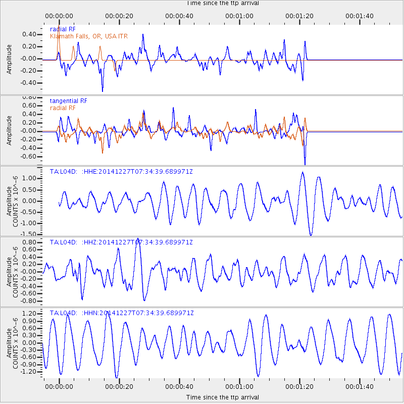
L04D Klamath Falls, OR, USA - Earthquake Result Viewer
*The percent match for this event was below the threshold and hence no stack was calculated.
| Earthquake location: |
Reykjanes Ridge |
| Earthquake latitude/longitude: |
55.4/-35.1 |
| Earthquake time(UTC): |
2014/12/27 (361) 07:25:37 GMT |
| Earthquake Depth: |
10 km |
| Earthquake Magnitude: |
5.4 MW, 5.3 mb, 5.2 Ms_20 |
| Earthquake Catalog/Contributor: |
ISC/ISC |
|
| Network: |
TA USArray Transportable Network (new EarthScope stations) |
| Station: |
L04D Klamath Falls, OR, USA |
| Lat/Lon: |
42.22 N/122.30 W |
| Elevation: |
1437 m |
|
| Distance: |
55.2 deg |
| Az: |
295.355 deg |
| Baz: |
43.938 deg |
| Ray Param: |
$rayparam |
*The percent match for this event was below the threshold and hence was not used in the summary stack. |
|
| Radial Match: |
32.084244 % |
| Radial Bump: |
371 |
| Transverse Match: |
72.03534 % |
| Transverse Bump: |
339 |
| SOD ConfigId: |
3390531 |
| Insert Time: |
2019-04-15 19:47:13.117 +0000 |
| GWidth: |
2.5 |
| Max Bumps: |
400 |
| Tol: |
0.001 |
|
Signal To Noise
| Channel | StoN | STA | LTA |
| TA:L04D: :HHZ:20141227T07:34:39.689971Z | 0.4694376 | 1.9140256E-7 | 4.0772738E-7 |
| TA:L04D: :HHN:20141227T07:34:39.689971Z | 2.8437872 | 8.265531E-7 | 2.9065225E-7 |
| TA:L04D: :HHE:20141227T07:34:39.689971Z | 1.8788489 | 4.6999443E-7 | 2.501502E-7 |
| Arrivals |
| Ps | |
| PpPs | |
| PsPs/PpSs | |


