You are here: Home > Network List > TA - USArray Transportable Network (new EarthScope stations) Stations List
> Station R54A Victor, WV, USA > Earthquake Result Viewer
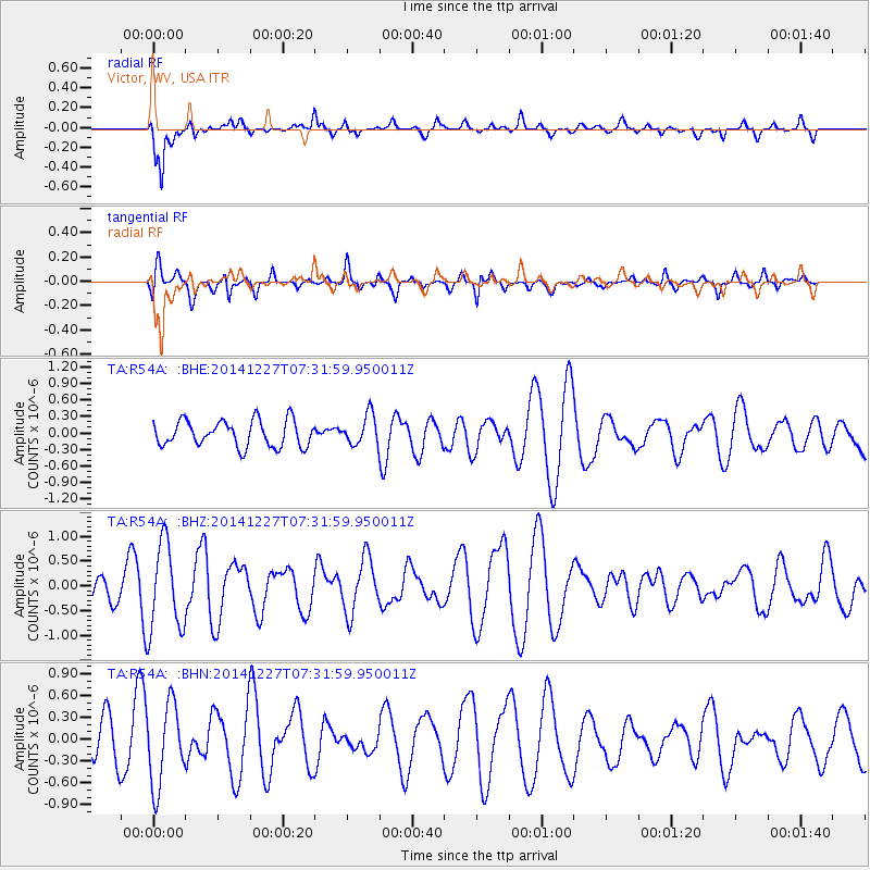
R54A Victor, WV, USA - Earthquake Result Viewer
*The percent match for this event was below the threshold and hence no stack was calculated.
| Earthquake location: |
Reykjanes Ridge |
| Earthquake latitude/longitude: |
55.4/-35.1 |
| Earthquake time(UTC): |
2014/12/27 (361) 07:25:37 GMT |
| Earthquake Depth: |
10 km |
| Earthquake Magnitude: |
5.4 MW, 5.3 mb, 5.2 Ms_20 |
| Earthquake Catalog/Contributor: |
ISC/ISC |
|
| Network: |
TA USArray Transportable Network (new EarthScope stations) |
| Station: |
R54A Victor, WV, USA |
| Lat/Lon: |
38.18 N/80.99 W |
| Elevation: |
512 m |
|
| Distance: |
35.0 deg |
| Az: |
259.987 deg |
| Baz: |
45.459 deg |
| Ray Param: |
$rayparam |
*The percent match for this event was below the threshold and hence was not used in the summary stack. |
|
| Radial Match: |
82.964226 % |
| Radial Bump: |
400 |
| Transverse Match: |
51.69503 % |
| Transverse Bump: |
383 |
| SOD ConfigId: |
3390531 |
| Insert Time: |
2019-04-15 19:47:24.670 +0000 |
| GWidth: |
2.5 |
| Max Bumps: |
400 |
| Tol: |
0.001 |
|
Signal To Noise
| Channel | StoN | STA | LTA |
| TA:R54A: :BHZ:20141227T07:31:59.950011Z | 3.180911 | 8.8490606E-7 | 2.7819266E-7 |
| TA:R54A: :BHN:20141227T07:31:59.950011Z | 2.1338005 | 5.5797165E-7 | 2.6149198E-7 |
| TA:R54A: :BHE:20141227T07:31:59.950011Z | 1.1694663 | 2.761996E-7 | 2.3617577E-7 |
| Arrivals |
| Ps | |
| PpPs | |
| PsPs/PpSs | |


