You are here: Home > Network List > TA - USArray Transportable Network (new EarthScope stations) Stations List
> Station W56A Indian Trail, NC, USA > Earthquake Result Viewer
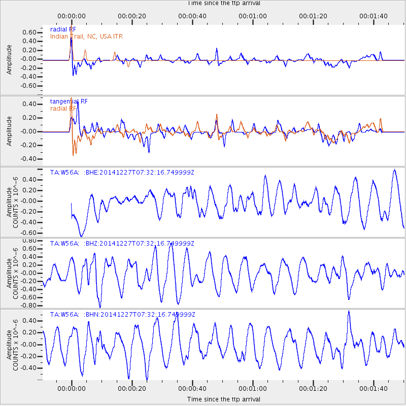
W56A Indian Trail, NC, USA - Earthquake Result Viewer
*The percent match for this event was below the threshold and hence no stack was calculated.
| Earthquake location: |
Reykjanes Ridge |
| Earthquake latitude/longitude: |
55.4/-35.1 |
| Earthquake time(UTC): |
2014/12/27 (361) 07:25:37 GMT |
| Earthquake Depth: |
10 km |
| Earthquake Magnitude: |
5.4 MW, 5.3 mb, 5.2 Ms_20 |
| Earthquake Catalog/Contributor: |
ISC/ISC |
|
| Network: |
TA USArray Transportable Network (new EarthScope stations) |
| Station: |
W56A Indian Trail, NC, USA |
| Lat/Lon: |
35.13 N/80.58 W |
| Elevation: |
177 m |
|
| Distance: |
37.0 deg |
| Az: |
255.997 deg |
| Baz: |
42.473 deg |
| Ray Param: |
$rayparam |
*The percent match for this event was below the threshold and hence was not used in the summary stack. |
|
| Radial Match: |
64.18568 % |
| Radial Bump: |
400 |
| Transverse Match: |
59.593502 % |
| Transverse Bump: |
400 |
| SOD ConfigId: |
3390531 |
| Insert Time: |
2019-04-15 19:47:32.531 +0000 |
| GWidth: |
2.5 |
| Max Bumps: |
400 |
| Tol: |
0.001 |
|
Signal To Noise
| Channel | StoN | STA | LTA |
| TA:W56A: :BHZ:20141227T07:32:16.749999Z | 1.1487916 | 3.0362185E-7 | 2.6429674E-7 |
| TA:W56A: :BHN:20141227T07:32:16.749999Z | 1.1677473 | 2.7801502E-7 | 2.3807807E-7 |
| TA:W56A: :BHE:20141227T07:32:16.749999Z | 1.0725696 | 2.2445448E-7 | 2.0926798E-7 |
| Arrivals |
| Ps | |
| PpPs | |
| PsPs/PpSs | |


