You are here: Home > Network List > US - United States National Seismic Network Stations List
> Station AMTX Amarillo, Texas, USA > Earthquake Result Viewer
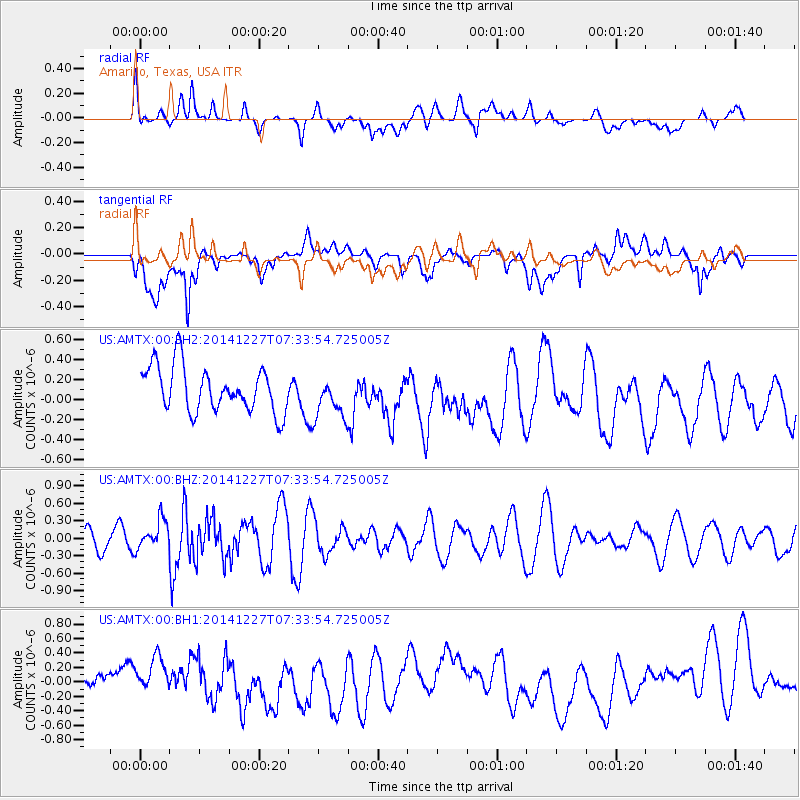
AMTX Amarillo, Texas, USA - Earthquake Result Viewer
*The percent match for this event was below the threshold and hence no stack was calculated.
| Earthquake location: |
Reykjanes Ridge |
| Earthquake latitude/longitude: |
55.4/-35.1 |
| Earthquake time(UTC): |
2014/12/27 (361) 07:25:37 GMT |
| Earthquake Depth: |
10 km |
| Earthquake Magnitude: |
5.4 MW, 5.3 mb, 5.2 Ms_20 |
| Earthquake Catalog/Contributor: |
ISC/ISC |
|
| Network: |
US United States National Seismic Network |
| Station: |
AMTX Amarillo, Texas, USA |
| Lat/Lon: |
34.53 N/101.41 W |
| Elevation: |
1010 m |
|
| Distance: |
49.2 deg |
| Az: |
273.697 deg |
| Baz: |
43.586 deg |
| Ray Param: |
$rayparam |
*The percent match for this event was below the threshold and hence was not used in the summary stack. |
|
| Radial Match: |
47.69886 % |
| Radial Bump: |
400 |
| Transverse Match: |
48.525795 % |
| Transverse Bump: |
400 |
| SOD ConfigId: |
3390531 |
| Insert Time: |
2019-04-15 19:48:04.440 +0000 |
| GWidth: |
2.5 |
| Max Bumps: |
400 |
| Tol: |
0.001 |
|
Signal To Noise
| Channel | StoN | STA | LTA |
| US:AMTX:00:BHZ:20141227T07:33:54.725005Z | 1.0978616 | 2.5968427E-7 | 2.3653642E-7 |
| US:AMTX:00:BH1:20141227T07:33:54.725005Z | 1.6647581 | 3.5727226E-7 | 2.1460912E-7 |
| US:AMTX:00:BH2:20141227T07:33:54.725005Z | 1.0215042 | 2.2981726E-7 | 2.2497926E-7 |
| Arrivals |
| Ps | |
| PpPs | |
| PsPs/PpSs | |


