You are here: Home > Network List > TA - USArray Transportable Network (new EarthScope stations) Stations List
> Station C06D Leavenworth, WQ, USA > Earthquake Result Viewer
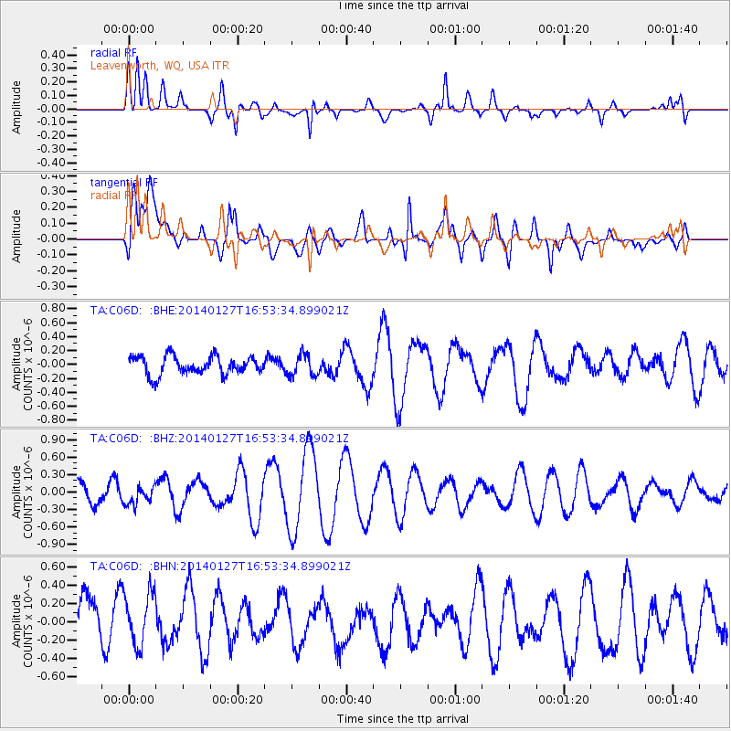
C06D Leavenworth, WQ, USA - Earthquake Result Viewer
*The percent match for this event was below the threshold and hence no stack was calculated.
| Earthquake location: |
Southern Bolivia |
| Earthquake latitude/longitude: |
-19.3/-63.9 |
| Earthquake time(UTC): |
2014/01/27 (027) 16:42:37 GMT |
| Earthquake Depth: |
600 km |
| Earthquake Magnitude: |
5.6 MWB |
| Earthquake Catalog/Contributor: |
NEIC PDE/NEIC COMCAT |
|
| Network: |
TA USArray Transportable Network (new EarthScope stations) |
| Station: |
C06D Leavenworth, WQ, USA |
| Lat/Lon: |
47.92 N/120.89 W |
| Elevation: |
544 m |
|
| Distance: |
84.0 deg |
| Az: |
325.459 deg |
| Baz: |
127.214 deg |
| Ray Param: |
$rayparam |
*The percent match for this event was below the threshold and hence was not used in the summary stack. |
|
| Radial Match: |
57.233585 % |
| Radial Bump: |
400 |
| Transverse Match: |
49.261227 % |
| Transverse Bump: |
400 |
| SOD ConfigId: |
626651 |
| Insert Time: |
2014-04-20 12:51:54.219 +0000 |
| GWidth: |
2.5 |
| Max Bumps: |
400 |
| Tol: |
0.001 |
|
Signal To Noise
| Channel | StoN | STA | LTA |
| TA:C06D: :BHZ:20140127T16:53:34.899021Z | 0.67852885 | 1.5223597E-7 | 2.2436181E-7 |
| TA:C06D: :BHN:20140127T16:53:34.899021Z | 1.3966979 | 3.1782523E-7 | 2.2755475E-7 |
| TA:C06D: :BHE:20140127T16:53:34.899021Z | 1.1442547 | 1.5327913E-7 | 1.3395544E-7 |
| Arrivals |
| Ps | |
| PpPs | |
| PsPs/PpSs | |


