You are here: Home > Network List > TA - USArray Transportable Network (new EarthScope stations) Stations List
> Station G59A Clarenceville, QC, USA > Earthquake Result Viewer
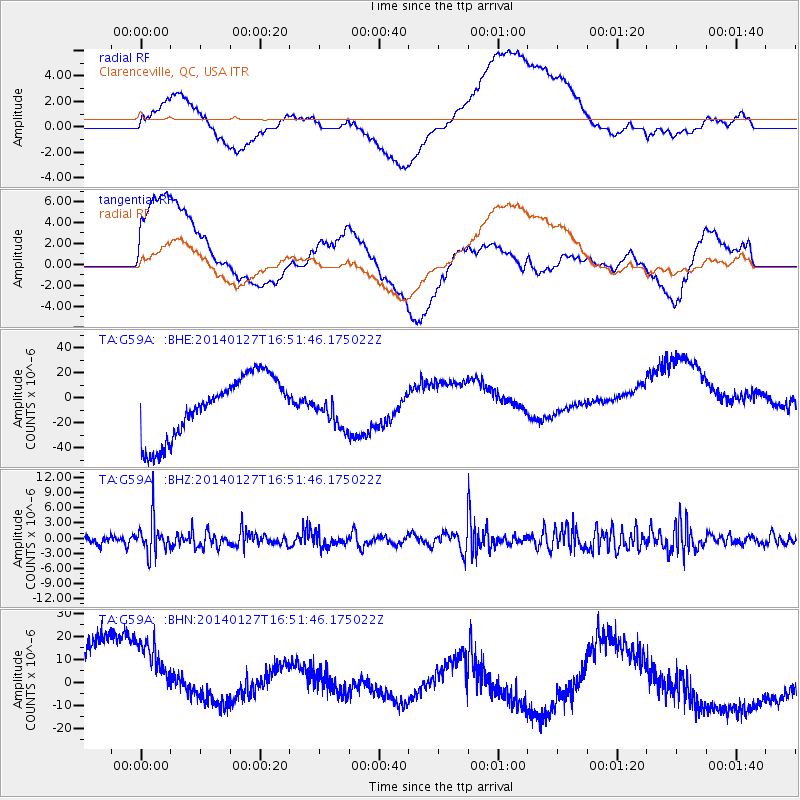
G59A Clarenceville, QC, USA - Earthquake Result Viewer
*The percent match for this event was below the threshold and hence no stack was calculated.
| Earthquake location: |
Southern Bolivia |
| Earthquake latitude/longitude: |
-19.3/-63.9 |
| Earthquake time(UTC): |
2014/01/27 (027) 16:42:37 GMT |
| Earthquake Depth: |
600 km |
| Earthquake Magnitude: |
5.6 MWB |
| Earthquake Catalog/Contributor: |
NEIC PDE/NEIC COMCAT |
|
| Network: |
TA USArray Transportable Network (new EarthScope stations) |
| Station: |
G59A Clarenceville, QC, USA |
| Lat/Lon: |
45.08 N/73.18 W |
| Elevation: |
36 m |
|
| Distance: |
64.6 deg |
| Az: |
352.747 deg |
| Baz: |
170.308 deg |
| Ray Param: |
$rayparam |
*The percent match for this event was below the threshold and hence was not used in the summary stack. |
|
| Radial Match: |
41.69885 % |
| Radial Bump: |
400 |
| Transverse Match: |
34.353214 % |
| Transverse Bump: |
400 |
| SOD ConfigId: |
626651 |
| Insert Time: |
2014-04-20 12:53:26.560 +0000 |
| GWidth: |
2.5 |
| Max Bumps: |
400 |
| Tol: |
0.001 |
|
Signal To Noise
| Channel | StoN | STA | LTA |
| TA:G59A: :BHZ:20140127T16:51:46.175022Z | 2.0876184 | 3.444649E-6 | 1.6500377E-6 |
| TA:G59A: :BHN:20140127T16:51:46.175022Z | 1.247141 | 3.063073E-5 | 2.4560757E-5 |
| TA:G59A: :BHE:20140127T16:51:46.175022Z | 0.5133437 | 1.25056995E-5 | 2.4361263E-5 |
| Arrivals |
| Ps | |
| PpPs | |
| PsPs/PpSs | |


