You are here: Home > Network List > TA - USArray Transportable Network (new EarthScope stations) Stations List
> Station I46A Reed City, MI, USA > Earthquake Result Viewer
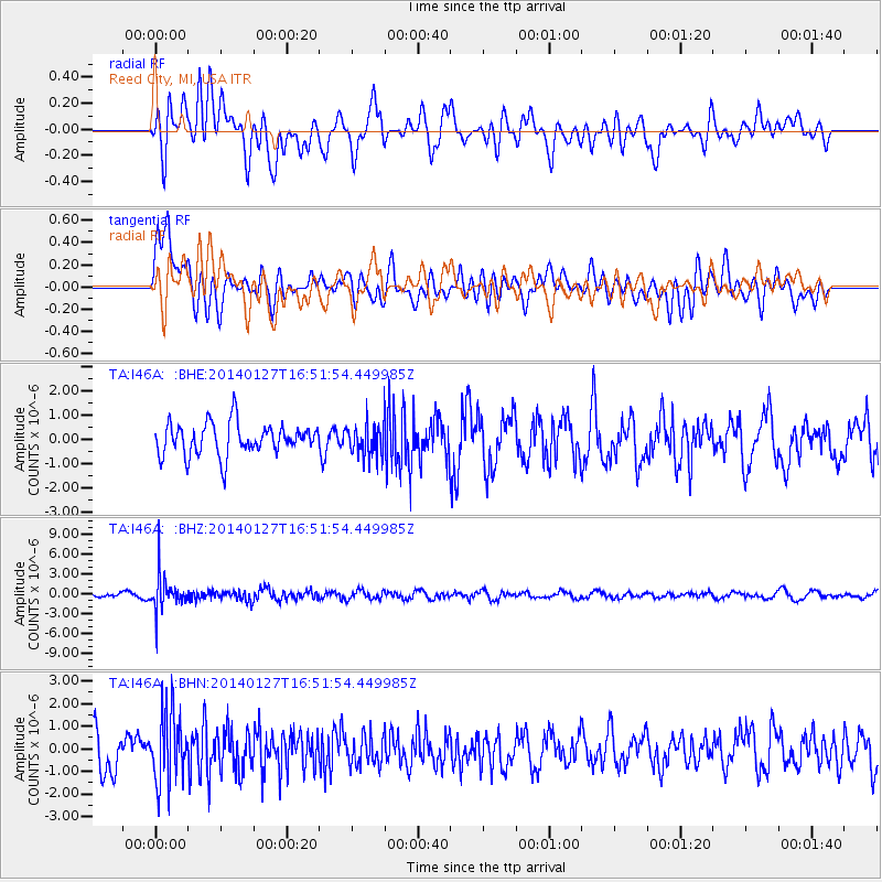
I46A Reed City, MI, USA - Earthquake Result Viewer
*The percent match for this event was below the threshold and hence no stack was calculated.
| Earthquake location: |
Southern Bolivia |
| Earthquake latitude/longitude: |
-19.3/-63.9 |
| Earthquake time(UTC): |
2014/01/27 (027) 16:42:37 GMT |
| Earthquake Depth: |
600 km |
| Earthquake Magnitude: |
5.6 MWB |
| Earthquake Catalog/Contributor: |
NEIC PDE/NEIC COMCAT |
|
| Network: |
TA USArray Transportable Network (new EarthScope stations) |
| Station: |
I46A Reed City, MI, USA |
| Lat/Lon: |
43.94 N/85.45 W |
| Elevation: |
359 m |
|
| Distance: |
65.9 deg |
| Az: |
343.12 deg |
| Baz: |
157.682 deg |
| Ray Param: |
$rayparam |
*The percent match for this event was below the threshold and hence was not used in the summary stack. |
|
| Radial Match: |
51.363407 % |
| Radial Bump: |
400 |
| Transverse Match: |
67.47172 % |
| Transverse Bump: |
400 |
| SOD ConfigId: |
626651 |
| Insert Time: |
2014-04-20 12:54:17.777 +0000 |
| GWidth: |
2.5 |
| Max Bumps: |
400 |
| Tol: |
0.001 |
|
Signal To Noise
| Channel | StoN | STA | LTA |
| TA:I46A: :BHZ:20140127T16:51:54.449985Z | 5.394615 | 2.707375E-6 | 5.018662E-7 |
| TA:I46A: :BHN:20140127T16:51:54.449985Z | 2.0464704 | 1.5658583E-6 | 7.651506E-7 |
| TA:I46A: :BHE:20140127T16:51:54.449985Z | 1.010422 | 6.622967E-7 | 6.5546544E-7 |
| Arrivals |
| Ps | |
| PpPs | |
| PsPs/PpSs | |


