You are here: Home > Network List > YB13 - Continental Dynamics/Cent. Anatolian Tectonics:Surface to Mantle Dynamics During Stations List
> Station AT09 Yukariulupinar,Malatya,Turkey > Earthquake Result Viewer
AT09 Yukariulupinar,Malatya,Turkey - Earthquake Result Viewer
| Earthquake location: |
Reykjanes Ridge |
| Earthquake latitude/longitude: |
55.4/-35.1 |
| Earthquake time(UTC): |
2014/12/27 (361) 07:25:37 GMT |
| Earthquake Depth: |
10 km |
| Earthquake Magnitude: |
5.4 MW, 5.3 mb, 5.2 Ms_20 |
| Earthquake Catalog/Contributor: |
ISC/ISC |
|
| Network: |
YB Continental Dynamics/Cent. Anatolian Tectonics:Surface to Mantle Dynamics During |
| Station: |
AT09 Yukariulupinar,Malatya,Turkey |
| Lat/Lon: |
38.40 N/37.57 E |
| Elevation: |
1429 m |
|
| Distance: |
50.1 deg |
| Az: |
77.878 deg |
| Baz: |
314.783 deg |
| Ray Param: |
0.06826966 |
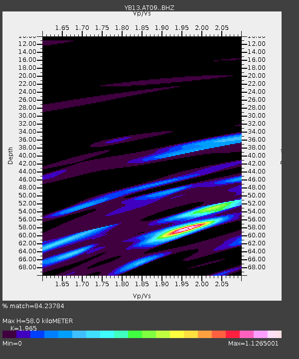
| Estimated Moho Depth: |
58.0 km |
| Estimated Crust Vp/Vs: |
1.97 |
| Assumed Crust Vp: |
6.35 km/s |
| Estimated Crust Vs: |
3.232 km/s |
| Estimated Crust Poisson's Ratio: |
0.33 |
|
| Radial Match: |
84.23784 % |
| Radial Bump: |
364 |
| Transverse Match: |
67.25758 % |
| Transverse Bump: |
400 |
| SOD ConfigId: |
3390531 |
| Insert Time: |
2019-04-15 19:49:42.449 +0000 |
| GWidth: |
2.5 |
| Max Bumps: |
400 |
| Tol: |
0.001 |
|

Signal To Noise
| Channel | StoN | STA | LTA |
| YB:AT09: :BHZ:20141227T07:34:02.239989Z | 3.924237 | 1.817232E-7 | 4.6307903E-8 |
| YB:AT09: :BHN:20141227T07:34:02.239989Z | 1.1671032 | 7.3508474E-8 | 6.29837E-8 |
| YB:AT09: :BHE:20141227T07:34:02.239989Z | 4.026582 | 1.3193666E-7 | 3.2766415E-8 |
| Arrivals |
| Ps | 9.3 SECOND |
| PpPs | 26 SECOND |
| PsPs/PpSs | 35 SECOND |


