You are here: Home > Network List > TA - USArray Transportable Network (new EarthScope stations) Stations List
> Station T60A Surry, VA, USA > Earthquake Result Viewer
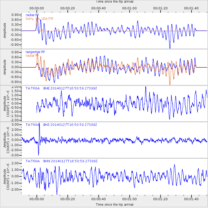
T60A Surry, VA, USA - Earthquake Result Viewer
*The percent match for this event was below the threshold and hence no stack was calculated.
| Earthquake location: |
Southern Bolivia |
| Earthquake latitude/longitude: |
-19.3/-63.9 |
| Earthquake time(UTC): |
2014/01/27 (027) 16:42:37 GMT |
| Earthquake Depth: |
600 km |
| Earthquake Magnitude: |
5.6 MWB |
| Earthquake Catalog/Contributor: |
NEIC PDE/NEIC COMCAT |
|
| Network: |
TA USArray Transportable Network (new EarthScope stations) |
| Station: |
T60A Surry, VA, USA |
| Lat/Lon: |
37.14 N/76.73 W |
| Elevation: |
11 m |
|
| Distance: |
57.4 deg |
| Az: |
347.851 deg |
| Baz: |
165.594 deg |
| Ray Param: |
$rayparam |
*The percent match for this event was below the threshold and hence was not used in the summary stack. |
|
| Radial Match: |
62.74349 % |
| Radial Bump: |
400 |
| Transverse Match: |
53.127853 % |
| Transverse Bump: |
400 |
| SOD ConfigId: |
626651 |
| Insert Time: |
2014-04-20 13:00:31.198 +0000 |
| GWidth: |
2.5 |
| Max Bumps: |
400 |
| Tol: |
0.001 |
|
Signal To Noise
| Channel | StoN | STA | LTA |
| TA:T60A: :BHZ:20140127T16:50:59.27399Z | 4.0999794 | 1.0584239E-6 | 2.5815345E-7 |
| TA:T60A: :BHN:20140127T16:50:59.27399Z | 1.5145135 | 9.1479393E-7 | 6.0401834E-7 |
| TA:T60A: :BHE:20140127T16:50:59.27399Z | 0.58031994 | 3.3970062E-7 | 5.8536784E-7 |
| Arrivals |
| Ps | |
| PpPs | |
| PsPs/PpSs | |


