You are here: Home > Network List > TA - USArray Transportable Network (new EarthScope stations) Stations List
> Station V53A Saluda, NC, USA > Earthquake Result Viewer
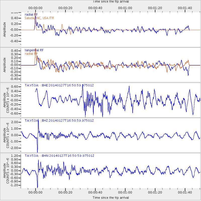
V53A Saluda, NC, USA - Earthquake Result Viewer
*The percent match for this event was below the threshold and hence no stack was calculated.
| Earthquake location: |
Southern Bolivia |
| Earthquake latitude/longitude: |
-19.3/-63.9 |
| Earthquake time(UTC): |
2014/01/27 (027) 16:42:37 GMT |
| Earthquake Depth: |
600 km |
| Earthquake Magnitude: |
5.6 MWB |
| Earthquake Catalog/Contributor: |
NEIC PDE/NEIC COMCAT |
|
| Network: |
TA USArray Transportable Network (new EarthScope stations) |
| Station: |
V53A Saluda, NC, USA |
| Lat/Lon: |
35.67 N/82.81 W |
| Elevation: |
681 m |
|
| Distance: |
57.5 deg |
| Az: |
341.781 deg |
| Baz: |
158.73 deg |
| Ray Param: |
$rayparam |
*The percent match for this event was below the threshold and hence was not used in the summary stack. |
|
| Radial Match: |
63.991222 % |
| Radial Bump: |
400 |
| Transverse Match: |
64.777985 % |
| Transverse Bump: |
400 |
| SOD ConfigId: |
626651 |
| Insert Time: |
2014-04-20 13:01:12.603 +0000 |
| GWidth: |
2.5 |
| Max Bumps: |
400 |
| Tol: |
0.001 |
|
Signal To Noise
| Channel | StoN | STA | LTA |
| TA:V53A: :BHZ:20140127T16:50:59.97501Z | 3.3422594 | 8.6863815E-7 | 2.598955E-7 |
| TA:V53A: :BHN:20140127T16:50:59.97501Z | 4.4362392 | 4.5655003E-7 | 1.02913745E-7 |
| TA:V53A: :BHE:20140127T16:50:59.97501Z | 1.7349136 | 3.1827253E-7 | 1.8345152E-7 |
| Arrivals |
| Ps | |
| PpPs | |
| PsPs/PpSs | |


