You are here: Home > Network List > TA - USArray Transportable Network (new EarthScope stations) Stations List
> Station W52A Murphy, NC, USA > Earthquake Result Viewer
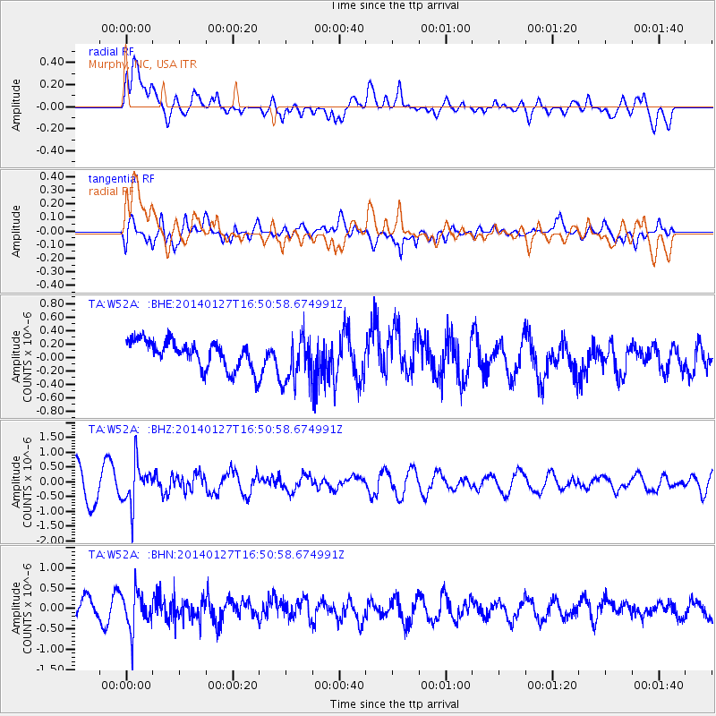
W52A Murphy, NC, USA - Earthquake Result Viewer
*The percent match for this event was below the threshold and hence no stack was calculated.
| Earthquake location: |
Southern Bolivia |
| Earthquake latitude/longitude: |
-19.3/-63.9 |
| Earthquake time(UTC): |
2014/01/27 (027) 16:42:37 GMT |
| Earthquake Depth: |
600 km |
| Earthquake Magnitude: |
5.6 MWB |
| Earthquake Catalog/Contributor: |
NEIC PDE/NEIC COMCAT |
|
| Network: |
TA USArray Transportable Network (new EarthScope stations) |
| Station: |
W52A Murphy, NC, USA |
| Lat/Lon: |
35.09 N/83.93 W |
| Elevation: |
519 m |
|
| Distance: |
57.3 deg |
| Az: |
340.522 deg |
| Baz: |
157.409 deg |
| Ray Param: |
$rayparam |
*The percent match for this event was below the threshold and hence was not used in the summary stack. |
|
| Radial Match: |
61.42317 % |
| Radial Bump: |
400 |
| Transverse Match: |
55.385963 % |
| Transverse Bump: |
400 |
| SOD ConfigId: |
626651 |
| Insert Time: |
2014-04-20 13:01:36.995 +0000 |
| GWidth: |
2.5 |
| Max Bumps: |
400 |
| Tol: |
0.001 |
|
Signal To Noise
| Channel | StoN | STA | LTA |
| TA:W52A: :BHZ:20140127T16:50:58.674991Z | 1.6928326 | 7.098928E-7 | 4.1935206E-7 |
| TA:W52A: :BHN:20140127T16:50:58.674991Z | 2.3223705 | 4.6165124E-7 | 1.9878449E-7 |
| TA:W52A: :BHE:20140127T16:50:58.674991Z | 1.7900883 | 3.6861647E-7 | 2.0592084E-7 |
| Arrivals |
| Ps | |
| PpPs | |
| PsPs/PpSs | |


