You are here: Home > Network List > TA - USArray Transportable Network (new EarthScope stations) Stations List
> Station Y59A Loris, SC, USA > Earthquake Result Viewer
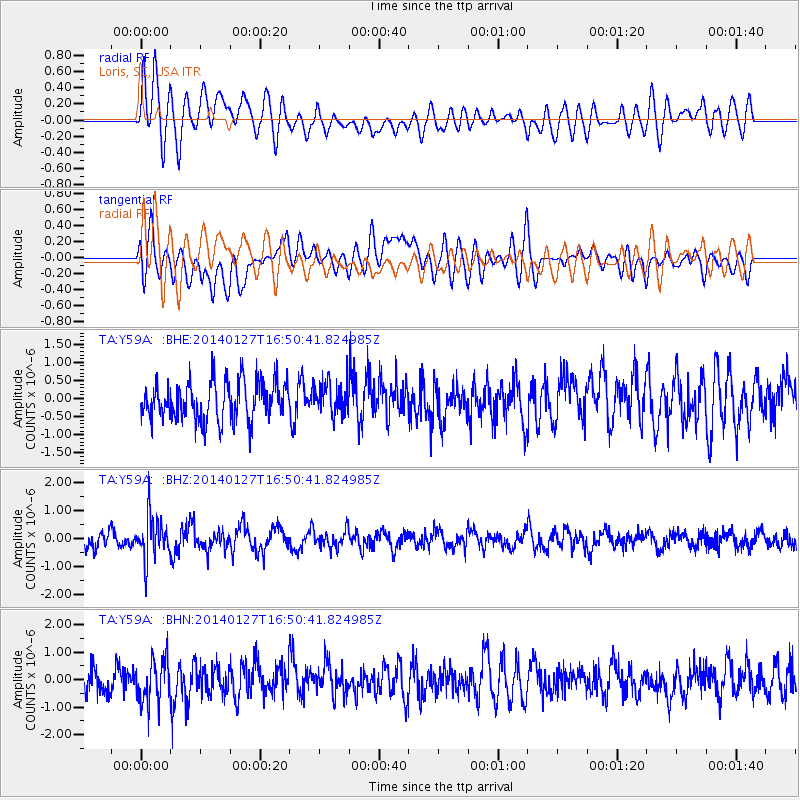
Y59A Loris, SC, USA - Earthquake Result Viewer
*The percent match for this event was below the threshold and hence no stack was calculated.
| Earthquake location: |
Southern Bolivia |
| Earthquake latitude/longitude: |
-19.3/-63.9 |
| Earthquake time(UTC): |
2014/01/27 (027) 16:42:37 GMT |
| Earthquake Depth: |
600 km |
| Earthquake Magnitude: |
5.6 MWB |
| Earthquake Catalog/Contributor: |
NEIC PDE/NEIC COMCAT |
|
| Network: |
TA USArray Transportable Network (new EarthScope stations) |
| Station: |
Y59A Loris, SC, USA |
| Lat/Lon: |
33.99 N/78.87 W |
| Elevation: |
2.0 m |
|
| Distance: |
54.8 deg |
| Az: |
344.795 deg |
| Baz: |
162.65 deg |
| Ray Param: |
$rayparam |
*The percent match for this event was below the threshold and hence was not used in the summary stack. |
|
| Radial Match: |
60.25078 % |
| Radial Bump: |
400 |
| Transverse Match: |
50.01286 % |
| Transverse Bump: |
400 |
| SOD ConfigId: |
626651 |
| Insert Time: |
2014-04-20 13:02:42.055 +0000 |
| GWidth: |
2.5 |
| Max Bumps: |
400 |
| Tol: |
0.001 |
|
Signal To Noise
| Channel | StoN | STA | LTA |
| TA:Y59A: :BHZ:20140127T16:50:41.824985Z | 2.8675423 | 7.464342E-7 | 2.6030452E-7 |
| TA:Y59A: :BHN:20140127T16:50:41.824985Z | 1.5866417 | 7.9213794E-7 | 4.9925444E-7 |
| TA:Y59A: :BHE:20140127T16:50:41.824985Z | 0.850494 | 4.526401E-7 | 5.3220845E-7 |
| Arrivals |
| Ps | |
| PpPs | |
| PsPs/PpSs | |


