You are here: Home > Network List > US - United States National Seismic Network Stations List
> Station ERPA Erie, Pennsylvania, USA > Earthquake Result Viewer
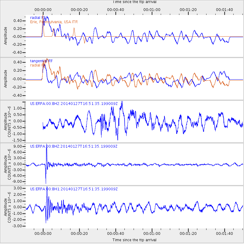
ERPA Erie, Pennsylvania, USA - Earthquake Result Viewer
*The percent match for this event was below the threshold and hence no stack was calculated.
| Earthquake location: |
Southern Bolivia |
| Earthquake latitude/longitude: |
-19.3/-63.9 |
| Earthquake time(UTC): |
2014/01/27 (027) 16:42:37 GMT |
| Earthquake Depth: |
600 km |
| Earthquake Magnitude: |
5.6 MWB |
| Earthquake Catalog/Contributor: |
NEIC PDE/NEIC COMCAT |
|
| Network: |
US United States National Seismic Network |
| Station: |
ERPA Erie, Pennsylvania, USA |
| Lat/Lon: |
42.12 N/79.99 W |
| Elevation: |
306 m |
|
| Distance: |
62.8 deg |
| Az: |
346.617 deg |
| Baz: |
162.908 deg |
| Ray Param: |
$rayparam |
*The percent match for this event was below the threshold and hence was not used in the summary stack. |
|
| Radial Match: |
46.526127 % |
| Radial Bump: |
400 |
| Transverse Match: |
49.055054 % |
| Transverse Bump: |
400 |
| SOD ConfigId: |
626651 |
| Insert Time: |
2014-04-20 13:03:39.945 +0000 |
| GWidth: |
2.5 |
| Max Bumps: |
400 |
| Tol: |
0.001 |
|
Signal To Noise
| Channel | StoN | STA | LTA |
| US:ERPA:00:BHZ:20140127T16:51:35.199009Z | 8.44512 | 2.7768613E-6 | 3.2881255E-7 |
| US:ERPA:00:BH1:20140127T16:51:35.199009Z | 3.598936 | 1.0862166E-6 | 3.0181602E-7 |
| US:ERPA:00:BH2:20140127T16:51:35.199009Z | 1.2715915 | 3.768748E-7 | 2.9638036E-7 |
| Arrivals |
| Ps | |
| PpPs | |
| PsPs/PpSs | |


