You are here: Home > Network List > II - Global Seismograph Network (GSN - IRIS/IDA) Stations List
> Station KIV Kislovodsk, Russia > Earthquake Result Viewer
KIV Kislovodsk, Russia - Earthquake Result Viewer

| Earthquake location: |
Eastern Sea Of Japan |
| Earthquake latitude/longitude: |
43.2/138.9 |
| Earthquake time(UTC): |
1996/12/22 (357) 14:53:27 GMT |
| Earthquake Depth: |
227 km |
| Earthquake Magnitude: |
6.0 MB, 6.5 UNKNOWN, 6.5 MW |
| Earthquake Catalog/Contributor: |
WHDF/NEIC |
|
| Network: |
II Global Seismograph Network (GSN - IRIS/IDA) |
| Station: |
KIV Kislovodsk, Russia |
| Lat/Lon: |
43.96 N/42.69 E |
| Elevation: |
1054 m |
|
| Distance: |
65.5 deg |
| Az: |
307.917 deg |
| Baz: |
53.006 deg |
| Ray Param: |
0.05753754 |
| Estimated Moho Depth: |
26.0 km |
| Estimated Crust Vp/Vs: |
1.60 |
| Assumed Crust Vp: |
6.247 km/s |
| Estimated Crust Vs: |
3.898 km/s |
| Estimated Crust Poisson's Ratio: |
0.18 |
|
| Radial Match: |
98.247025 % |
| Radial Bump: |
293 |
| Transverse Match: |
95.43408 % |
| Transverse Bump: |
400 |
| SOD ConfigId: |
6273 |
| Insert Time: |
2010-03-01 18:33:50.827 +0000 |
| GWidth: |
2.5 |
| Max Bumps: |
400 |
| Tol: |
0.001 |
|
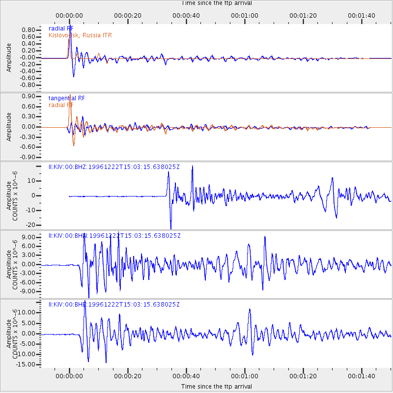
Signal To Noise
| Channel | StoN | STA | LTA |
| II:KIV:00:BHN:19961222T15:03:15.638025Z | 33.80844 | 2.3348596E-6 | 6.9061436E-8 |
| II:KIV:00:BHE:19961222T15:03:15.638025Z | 27.377045 | 2.4924664E-6 | 9.1042196E-8 |
| II:KIV:00:BHZ:19961222T15:03:15.638025Z | 85.154854 | 6.8292684E-6 | 8.019823E-8 |
| Arrivals |
| Ps | 2.6 SECOND |
| PpPs | 10 SECOND |
| PsPs/PpSs | 13 SECOND |


