You are here: Home > Network List > CI - Caltech Regional Seismic Network Stations List
> Station MPM Manuel Prospect Mine, California, USA > Earthquake Result Viewer
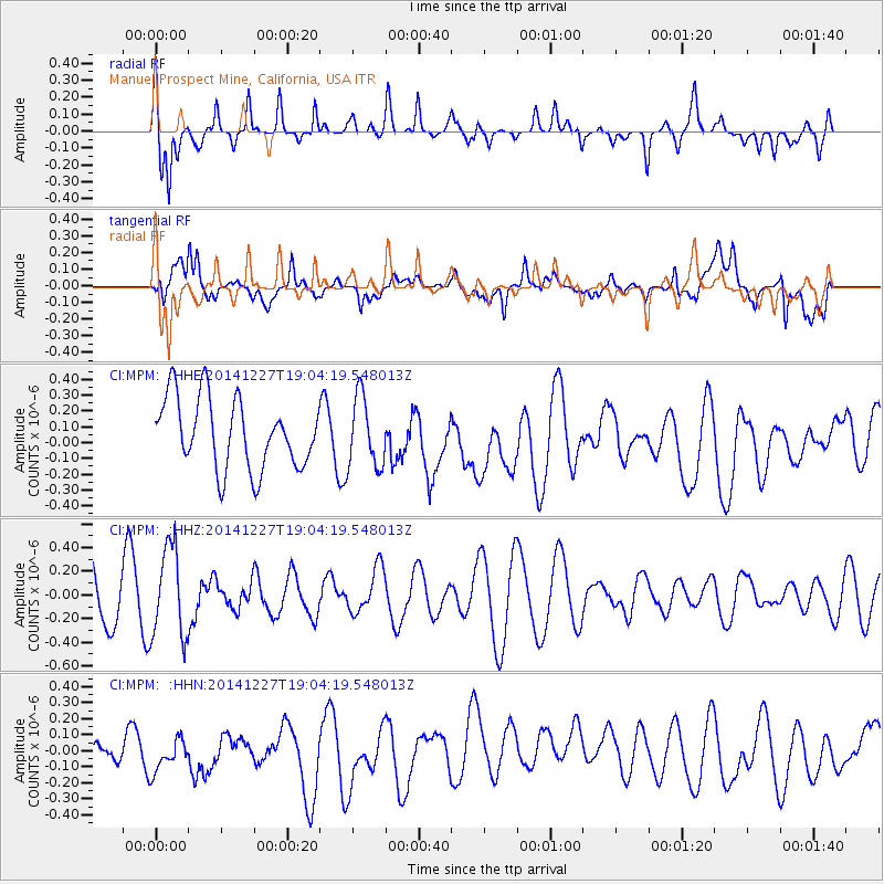
MPM Manuel Prospect Mine, California, USA - Earthquake Result Viewer
*The percent match for this event was below the threshold and hence no stack was calculated.
| Earthquake location: |
Fiji Islands Region |
| Earthquake latitude/longitude: |
-17.9/-179.5 |
| Earthquake time(UTC): |
2014/12/27 (361) 18:53:47 GMT |
| Earthquake Depth: |
622 km |
| Earthquake Magnitude: |
5.5 MW, 5.1 mb, 5.5 Mwb, 5.5 Mwc |
| Earthquake Catalog/Contributor: |
ISC/ISC |
|
| Network: |
CI Caltech Regional Seismic Network |
| Station: |
MPM Manuel Prospect Mine, California, USA |
| Lat/Lon: |
36.06 N/117.49 W |
| Elevation: |
185 m |
|
| Distance: |
79.5 deg |
| Az: |
46.696 deg |
| Baz: |
238.765 deg |
| Ray Param: |
$rayparam |
*The percent match for this event was below the threshold and hence was not used in the summary stack. |
|
| Radial Match: |
62.622066 % |
| Radial Bump: |
400 |
| Transverse Match: |
53.08114 % |
| Transverse Bump: |
400 |
| SOD ConfigId: |
3390531 |
| Insert Time: |
2019-04-15 19:57:57.798 +0000 |
| GWidth: |
2.5 |
| Max Bumps: |
400 |
| Tol: |
0.001 |
|
Signal To Noise
| Channel | StoN | STA | LTA |
| CI:MPM: :HHZ:20141227T19:04:19.548013Z | 2.6678357 | 3.8290213E-7 | 1.4352538E-7 |
| CI:MPM: :HHN:20141227T19:04:19.548013Z | 0.93577886 | 1.109391E-7 | 1.18552684E-7 |
| CI:MPM: :HHE:20141227T19:04:19.548013Z | 1.0065228 | 2.2219345E-7 | 2.2075353E-7 |
| Arrivals |
| Ps | |
| PpPs | |
| PsPs/PpSs | |


