You are here: Home > Network List > II - Global Seismograph Network (GSN - IRIS/IDA) Stations List
> Station WRAB Tennant Creek, NT, Australia > Earthquake Result Viewer
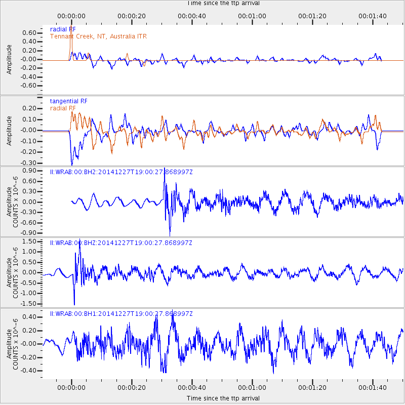
WRAB Tennant Creek, NT, Australia - Earthquake Result Viewer
*The percent match for this event was below the threshold and hence no stack was calculated.
| Earthquake location: |
Fiji Islands Region |
| Earthquake latitude/longitude: |
-17.9/-179.5 |
| Earthquake time(UTC): |
2014/12/27 (361) 18:53:47 GMT |
| Earthquake Depth: |
622 km |
| Earthquake Magnitude: |
5.5 MW, 5.1 mb, 5.5 Mwb, 5.5 Mwc |
| Earthquake Catalog/Contributor: |
ISC/ISC |
|
| Network: |
II Global Seismograph Network (GSN - IRIS/IDA) |
| Station: |
WRAB Tennant Creek, NT, Australia |
| Lat/Lon: |
19.93 S/134.36 E |
| Elevation: |
366 m |
|
| Distance: |
43.6 deg |
| Az: |
259.702 deg |
| Baz: |
95.349 deg |
| Ray Param: |
$rayparam |
*The percent match for this event was below the threshold and hence was not used in the summary stack. |
|
| Radial Match: |
47.895092 % |
| Radial Bump: |
400 |
| Transverse Match: |
74.217255 % |
| Transverse Bump: |
400 |
| SOD ConfigId: |
3390531 |
| Insert Time: |
2019-04-15 19:58:46.118 +0000 |
| GWidth: |
2.5 |
| Max Bumps: |
400 |
| Tol: |
0.001 |
|
Signal To Noise
| Channel | StoN | STA | LTA |
| II:WRAB:00:BHZ:20141227T19:00:27.868997Z | 3.440754 | 5.9277966E-7 | 1.7228191E-7 |
| II:WRAB:00:BH1:20141227T19:00:27.868997Z | 1.2003276 | 1.175632E-7 | 9.794259E-8 |
| II:WRAB:00:BH2:20141227T19:00:27.868997Z | 3.9198365 | 3.9161185E-7 | 9.9905144E-8 |
| Arrivals |
| Ps | |
| PpPs | |
| PsPs/PpSs | |


