You are here: Home > Network List > UU - University of Utah Regional Network Stations List
> Station CCUT Cedar City, UT, USA > Earthquake Result Viewer
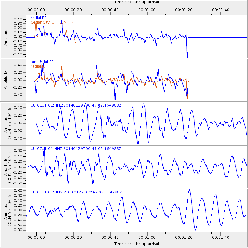
CCUT Cedar City, UT, USA - Earthquake Result Viewer
*The percent match for this event was below the threshold and hence no stack was calculated.
| Earthquake location: |
Solomon Islands |
| Earthquake latitude/longitude: |
-9.6/161.2 |
| Earthquake time(UTC): |
2014/01/29 (029) 00:32:28 GMT |
| Earthquake Depth: |
41 km |
| Earthquake Magnitude: |
5.6 MWB, 5.6 MWC |
| Earthquake Catalog/Contributor: |
NEIC PDE/NEIC COMCAT |
|
| Network: |
UU University of Utah Regional Network |
| Station: |
CCUT Cedar City, UT, USA |
| Lat/Lon: |
37.55 N/113.36 W |
| Elevation: |
2127 m |
|
| Distance: |
92.2 deg |
| Az: |
52.448 deg |
| Baz: |
259.651 deg |
| Ray Param: |
$rayparam |
*The percent match for this event was below the threshold and hence was not used in the summary stack. |
|
| Radial Match: |
56.933666 % |
| Radial Bump: |
345 |
| Transverse Match: |
77.564125 % |
| Transverse Bump: |
369 |
| SOD ConfigId: |
626651 |
| Insert Time: |
2014-04-20 13:18:45.504 +0000 |
| GWidth: |
2.5 |
| Max Bumps: |
400 |
| Tol: |
0.001 |
|
Signal To Noise
| Channel | StoN | STA | LTA |
| UU:CCUT:01:HHZ:20140129T00:45:02.164988Z | 1.983038 | 2.5907332E-7 | 1.3064466E-7 |
| UU:CCUT:01:HHN:20140129T00:45:02.164988Z | 0.55984145 | 1.4591106E-7 | 2.6062924E-7 |
| UU:CCUT:01:HHE:20140129T00:45:02.164988Z | 1.5420792 | 3.2305783E-7 | 2.0949496E-7 |
| Arrivals |
| Ps | |
| PpPs | |
| PsPs/PpSs | |


