You are here: Home > Network List > IU - Global Seismograph Network (GSN - IRIS/USGS) Stations List
> Station PMG Port Moresby, New Guinea > Earthquake Result Viewer
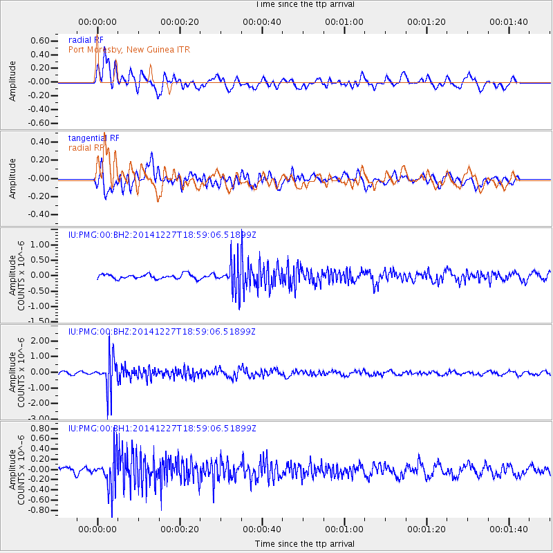
PMG Port Moresby, New Guinea - Earthquake Result Viewer
*The percent match for this event was below the threshold and hence no stack was calculated.
| Earthquake location: |
Fiji Islands Region |
| Earthquake latitude/longitude: |
-17.9/-179.5 |
| Earthquake time(UTC): |
2014/12/27 (361) 18:53:47 GMT |
| Earthquake Depth: |
622 km |
| Earthquake Magnitude: |
5.5 MW, 5.1 mb, 5.5 Mwb, 5.5 Mwc |
| Earthquake Catalog/Contributor: |
ISC/ISC |
|
| Network: |
IU Global Seismograph Network (GSN - IRIS/USGS) |
| Station: |
PMG Port Moresby, New Guinea |
| Lat/Lon: |
9.40 S/147.16 E |
| Elevation: |
90 m |
|
| Distance: |
33.4 deg |
| Az: |
280.199 deg |
| Baz: |
108.266 deg |
| Ray Param: |
$rayparam |
*The percent match for this event was below the threshold and hence was not used in the summary stack. |
|
| Radial Match: |
68.97627 % |
| Radial Bump: |
400 |
| Transverse Match: |
51.835453 % |
| Transverse Bump: |
400 |
| SOD ConfigId: |
3390531 |
| Insert Time: |
2019-04-15 19:58:52.507 +0000 |
| GWidth: |
2.5 |
| Max Bumps: |
400 |
| Tol: |
0.001 |
|
Signal To Noise
| Channel | StoN | STA | LTA |
| IU:PMG:00:BHZ:20141227T18:59:06.51899Z | 7.6235375 | 1.0177806E-6 | 1.3350504E-7 |
| IU:PMG:00:BH1:20141227T18:59:06.51899Z | 2.8384159 | 3.268085E-7 | 1.15137645E-7 |
| IU:PMG:00:BH2:20141227T18:59:06.51899Z | 6.036239 | 4.6080706E-7 | 7.634009E-8 |
| Arrivals |
| Ps | |
| PpPs | |
| PsPs/PpSs | |


