You are here: Home > Network List > US - United States National Seismic Network Stations List
> Station MSO Missoula, Montana, USA > Earthquake Result Viewer
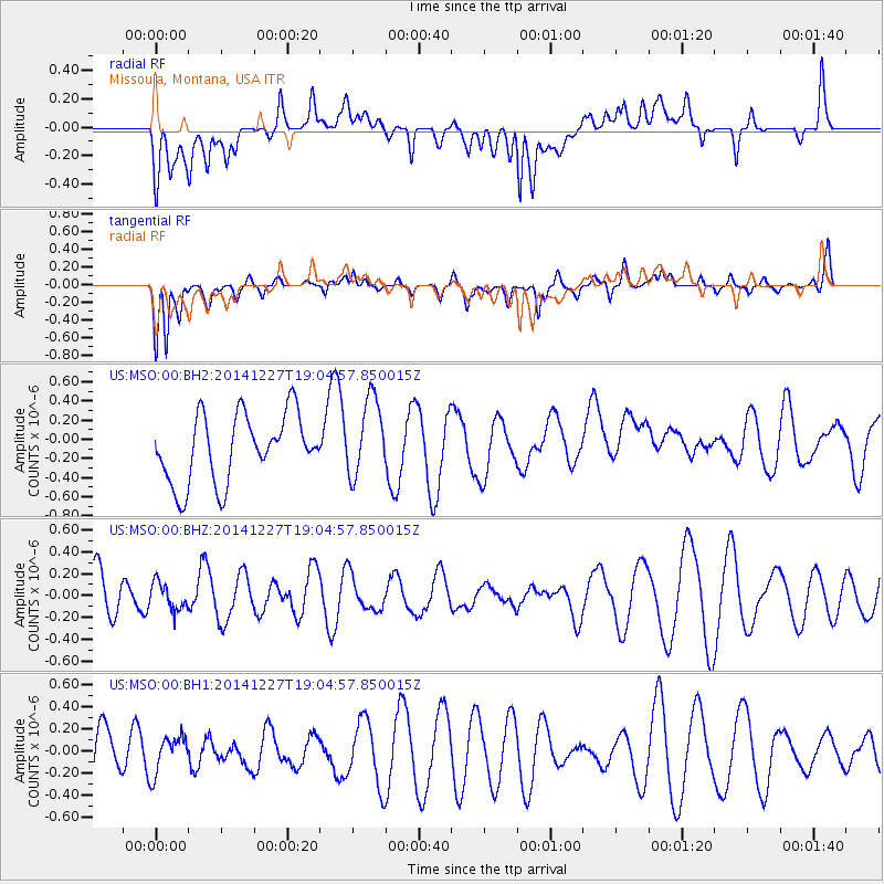
MSO Missoula, Montana, USA - Earthquake Result Viewer
*The percent match for this event was below the threshold and hence no stack was calculated.
| Earthquake location: |
Fiji Islands Region |
| Earthquake latitude/longitude: |
-17.9/-179.5 |
| Earthquake time(UTC): |
2014/12/27 (361) 18:53:47 GMT |
| Earthquake Depth: |
622 km |
| Earthquake Magnitude: |
5.5 MW, 5.1 mb, 5.5 Mwb, 5.5 Mwc |
| Earthquake Catalog/Contributor: |
ISC/ISC |
|
| Network: |
US United States National Seismic Network |
| Station: |
MSO Missoula, Montana, USA |
| Lat/Lon: |
46.83 N/113.94 W |
| Elevation: |
1264 m |
|
| Distance: |
87.2 deg |
| Az: |
38.738 deg |
| Baz: |
240.19 deg |
| Ray Param: |
$rayparam |
*The percent match for this event was below the threshold and hence was not used in the summary stack. |
|
| Radial Match: |
44.514076 % |
| Radial Bump: |
400 |
| Transverse Match: |
71.72107 % |
| Transverse Bump: |
400 |
| SOD ConfigId: |
3390531 |
| Insert Time: |
2019-04-15 20:00:35.160 +0000 |
| GWidth: |
2.5 |
| Max Bumps: |
400 |
| Tol: |
0.001 |
|
Signal To Noise
| Channel | StoN | STA | LTA |
| US:MSO:00:BHZ:20141227T19:04:57.850015Z | 0.42056102 | 1.2540589E-7 | 2.9818716E-7 |
| US:MSO:00:BH1:20141227T19:04:57.850015Z | 0.9024011 | 1.7002837E-7 | 1.8841773E-7 |
| US:MSO:00:BH2:20141227T19:04:57.850015Z | 1.1680627 | 4.1443246E-7 | 3.548033E-7 |
| Arrivals |
| Ps | |
| PpPs | |
| PsPs/PpSs | |


