You are here: Home > Network List > CI - Caltech Regional Seismic Network Stations List
> Station SWS Sam W. Stewart, Westmorland, CA, USA > Earthquake Result Viewer
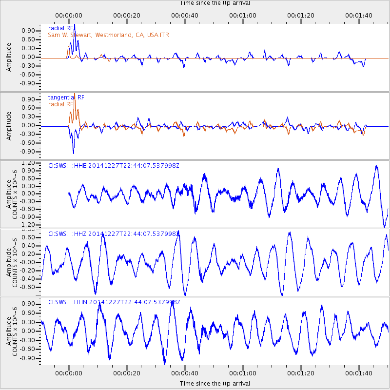
SWS Sam W. Stewart, Westmorland, CA, USA - Earthquake Result Viewer
*The percent match for this event was below the threshold and hence no stack was calculated.
| Earthquake location: |
Central Mid-Atlantic Ridge |
| Earthquake latitude/longitude: |
-0.7/-20.7 |
| Earthquake time(UTC): |
2014/12/27 (361) 22:31:18 GMT |
| Earthquake Depth: |
10 km |
| Earthquake Magnitude: |
5.0 MW, 5.3 mb |
| Earthquake Catalog/Contributor: |
ISC/ISC |
|
| Network: |
CI Caltech Regional Seismic Network |
| Station: |
SWS Sam W. Stewart, Westmorland, CA, USA |
| Lat/Lon: |
32.94 N/115.80 W |
| Elevation: |
140 m |
|
| Distance: |
94.6 deg |
| Az: |
302.825 deg |
| Baz: |
87.804 deg |
| Ray Param: |
$rayparam |
*The percent match for this event was below the threshold and hence was not used in the summary stack. |
|
| Radial Match: |
78.20224 % |
| Radial Bump: |
400 |
| Transverse Match: |
54.340412 % |
| Transverse Bump: |
400 |
| SOD ConfigId: |
3390531 |
| Insert Time: |
2019-04-15 20:03:50.795 +0000 |
| GWidth: |
2.5 |
| Max Bumps: |
400 |
| Tol: |
0.001 |
|
Signal To Noise
| Channel | StoN | STA | LTA |
| CI:SWS: :HHZ:20141227T22:44:07.537998Z | 0.9008537 | 2.4649214E-7 | 2.736206E-7 |
| CI:SWS: :HHN:20141227T22:44:07.537998Z | 1.5585887 | 3.483043E-7 | 2.2347415E-7 |
| CI:SWS: :HHE:20141227T22:44:07.537998Z | 0.92414457 | 1.9274762E-7 | 2.085687E-7 |
| Arrivals |
| Ps | |
| PpPs | |
| PsPs/PpSs | |


