LPAZ La Paz , Bolivia - Earthquake Result Viewer
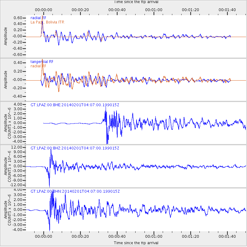
Earthquake location: South Sandwich Islands Region
Earthquake latitude/longitude: -56.8/-27.3
Earthquake time(UTC): 2014/02/01 (032) 03:58:43 GMT
Earthquake Depth: 130 km
Earthquake Magnitude: 6.1 MWW, 6.1 MWC, 6.1 MWB, 6.2 MWC
Earthquake Catalog/Contributor: NEIC PDE/NEIC COMCAT
Network: GT Global Telemetered Seismograph Network (USAF/USGS)
Station: LPAZ La Paz , Bolivia
Lat/Lon: 16.17 S/68.08 W
Elevation: 4817 m
Distance: 50.8 deg
Az: 306.023 deg
Baz: 152.438 deg
Ray Param: 0.06736638
Estimated Moho Depth: 27.5 km
Estimated Crust Vp/Vs: 1.60
Assumed Crust Vp: 6.454 km/s
Estimated Crust Vs: 4.034 km/s
Estimated Crust Poisson's Ratio: 0.18
Radial Match: 85.40905 %
Radial Bump: 400
Transverse Match: 83.265144 %
Transverse Bump: 400
SOD ConfigId: 626651
Insert Time: 2014-04-20 13:46:18.302 +0000
GWidth: 2.5
Max Bumps: 400
Tol: 0.001

Signal To Noise

ChannelStoNSTALTA
GT:LPAZ:00:BHZ:20140201T04:07:00.199015Z69.282154.3369937E-66.259901E-8
GT:LPAZ:00:BHN:20140201T04:07:00.199015Z20.5748251.486797E-67.226292E-8
GT:LPAZ:00:BHE:20140201T04:07:00.199015Z22.5517061.6352614E-67.251165E-8
Arrivals
Ps2.7 SECOND
PpPs10 SECOND
PsPs/PpSs13 SECOND