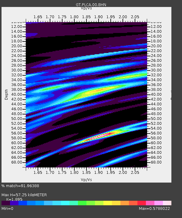
PLCA Paso Flores, Argentina - Earthquake Result Viewer

Earthquake location: South Sandwich Islands Region
Earthquake latitude/longitude: -56.8/-27.3
Earthquake time(UTC): 2014/02/01 (032) 03:58:43 GMT
Earthquake Depth: 130 km
Earthquake Magnitude: 6.1 MWW, 6.1 MWC, 6.1 MWB, 6.2 MWC
Earthquake Catalog/Contributor: NEIC PDE/NEIC COMCAT
Network: GT Global Telemetered Seismograph Network (USAF/USGS)
Station: PLCA Paso Flores, Argentina
Lat/Lon: 40.73 S/70.55 W
Elevation: 1050 m
Distance: 32.1 deg
Az: 281.442 deg
Baz: 134.843 deg
Ray Param: 0.07845027
Estimated Moho Depth: 57.25 km
Estimated Crust Vp/Vs: 1.89
Assumed Crust Vp: 6.597 km/s
Estimated Crust Vs: 3.482 km/s
Estimated Crust Poisson's Ratio: 0.31
Radial Match: 91.96388 %
Radial Bump: 242
Transverse Match: 80.87419 %
Transverse Bump: 400
SOD ConfigId: 626651
Insert Time: 2014-04-20 13:46:18.528 +0000
GWidth: 2.5
Max Bumps: 400
Tol: 0.001

Signal To Noise

ChannelStoNSTALTA
GT:PLCA:00:BHZ:20140201T04:04:28.249003Z6.53288171.4453351E-62.2124004E-7
GT:PLCA:00:BHN:20140201T04:04:28.249003Z5.9387789.32748E-71.570606E-7
GT:PLCA:00:BHE:20140201T04:04:28.249003Z2.2187563.9838926E-71.7955523E-7
Arrivals
Ps8.4 SECOND
PpPs23 SECOND
PsPs/PpSs32 SECOND