You are here: Home > Network List > TA - USArray Transportable Network (new EarthScope stations) Stations List
> Station T25A Trinidad, CO, USA > Earthquake Result Viewer
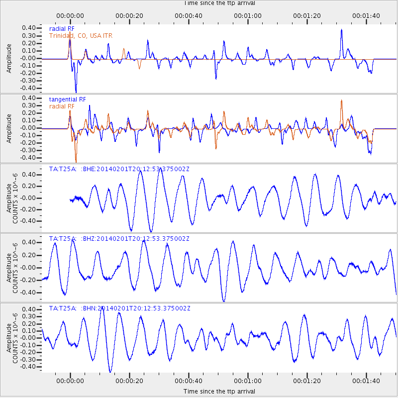
T25A Trinidad, CO, USA - Earthquake Result Viewer
*The percent match for this event was below the threshold and hence no stack was calculated.
| Earthquake location: |
Santa Cruz Islands |
| Earthquake latitude/longitude: |
-11.5/166.3 |
| Earthquake time(UTC): |
2014/02/01 (032) 20:00:01 GMT |
| Earthquake Depth: |
46 km |
| Earthquake Magnitude: |
5.7 MWW, 5.7 MWB, 5.8 MWC |
| Earthquake Catalog/Contributor: |
NEIC PDE/NEIC COMCAT |
|
| Network: |
TA USArray Transportable Network (new EarthScope stations) |
| Station: |
T25A Trinidad, CO, USA |
| Lat/Lon: |
37.14 N/104.41 W |
| Elevation: |
2017 m |
|
| Distance: |
96.3 deg |
| Az: |
53.502 deg |
| Baz: |
260.448 deg |
| Ray Param: |
$rayparam |
*The percent match for this event was below the threshold and hence was not used in the summary stack. |
|
| Radial Match: |
57.27788 % |
| Radial Bump: |
340 |
| Transverse Match: |
58.123573 % |
| Transverse Bump: |
400 |
| SOD ConfigId: |
626651 |
| Insert Time: |
2014-04-20 14:01:51.507 +0000 |
| GWidth: |
2.5 |
| Max Bumps: |
400 |
| Tol: |
0.001 |
|
Signal To Noise
| Channel | StoN | STA | LTA |
| TA:T25A: :BHZ:20140201T20:12:53.375002Z | 1.7174681 | 2.451131E-7 | 1.4271771E-7 |
| TA:T25A: :BHN:20140201T20:12:53.375002Z | 1.2344395 | 1.3983065E-7 | 1.132746E-7 |
| TA:T25A: :BHE:20140201T20:12:53.375002Z | 1.5713505 | 3.3164457E-7 | 2.1105704E-7 |
| Arrivals |
| Ps | |
| PpPs | |
| PsPs/PpSs | |


