You are here: Home > Network List > CI - Caltech Regional Seismic Network Stations List
> Station CIA CIA, Avalon Catalina Island, CA, USA > Earthquake Result Viewer
CIA CIA, Avalon Catalina Island, CA, USA - Earthquake Result Viewer
| Earthquake location: |
South Of Alaska |
| Earthquake latitude/longitude: |
53.8/-161.1 |
| Earthquake time(UTC): |
2002/05/25 (145) 05:36:31 GMT |
| Earthquake Depth: |
33 km |
| Earthquake Magnitude: |
5.5 MB, 6.1 MS, 6.5 MW, 6.4 MW |
| Earthquake Catalog/Contributor: |
WHDF/NEIC |
|
| Network: |
CI Caltech Regional Seismic Network |
| Station: |
CIA CIA, Avalon Catalina Island, CA, USA |
| Lat/Lon: |
33.40 N/118.41 W |
| Elevation: |
467 m |
|
| Distance: |
36.3 deg |
| Az: |
106.69 deg |
| Baz: |
317.235 deg |
| Ray Param: |
0.07668435 |
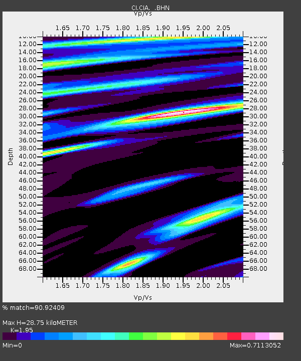
| Estimated Moho Depth: |
28.75 km |
| Estimated Crust Vp/Vs: |
1.95 |
| Assumed Crust Vp: |
6.048 km/s |
| Estimated Crust Vs: |
3.101 km/s |
| Estimated Crust Poisson's Ratio: |
0.32 |
|
| Radial Match: |
90.92409 % |
| Radial Bump: |
340 |
| Transverse Match: |
89.244804 % |
| Transverse Bump: |
381 |
| SOD ConfigId: |
3770 |
| Insert Time: |
2010-02-25 20:55:46.878 +0000 |
| GWidth: |
2.5 |
| Max Bumps: |
400 |
| Tol: |
0.001 |
|
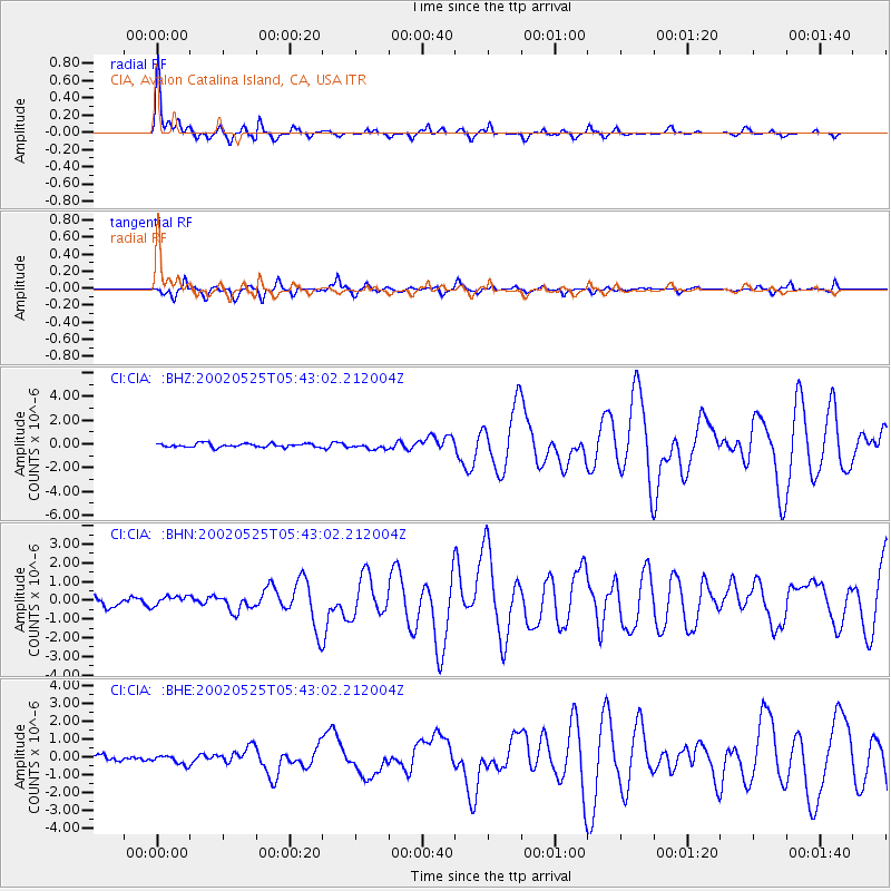
Signal To Noise
| Channel | StoN | STA | LTA |
| CI:CIA: :BHN:20020525T05:43:02.212004Z | 1.2573725 | 2.5196434E-7 | 2.0038956E-7 |
| CI:CIA: :BHE:20020525T05:43:02.212004Z | 1.5469093 | 2.5833822E-7 | 1.6700281E-7 |
| CI:CIA: :BHZ:20020525T05:43:02.212004Z | 1.5242956 | 2.4490944E-7 | 1.6067057E-7 |
| Arrivals |
| Ps | 4.8 SECOND |
| PpPs | 13 SECOND |
| PsPs/PpSs | 18 SECOND |


