You are here: Home > Network List > AU - Australian Seismological Centre Stations List
> Station MAW Mawson, Antarctica > Earthquake Result Viewer
MAW Mawson, Antarctica - Earthquake Result Viewer
| Earthquake location: |
South Of Kermadec Islands |
| Earthquake latitude/longitude: |
-32.9/-177.9 |
| Earthquake time(UTC): |
2014/02/02 (033) 09:26:37 GMT |
| Earthquake Depth: |
44 km |
| Earthquake Magnitude: |
6.5 MWW, 6.5 MWC, 6.5 MI |
| Earthquake Catalog/Contributor: |
NEIC PDE/NEIC COMCAT |
|
| Network: |
AU Australian Seismological Centre |
| Station: |
MAW Mawson, Antarctica |
| Lat/Lon: |
67.60 S/62.87 E |
| Elevation: |
12 m |
|
| Distance: |
70.0 deg |
| Az: |
200.842 deg |
| Baz: |
128.644 deg |
| Ray Param: |
0.055187467 |
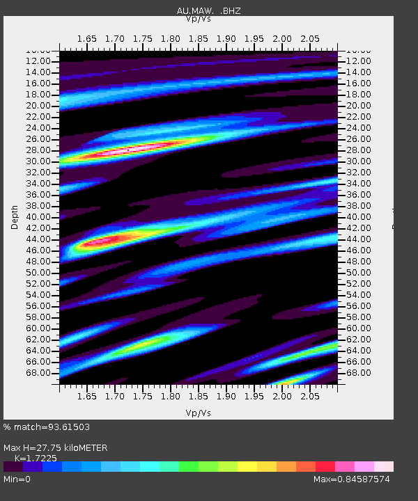
| Estimated Moho Depth: |
27.75 km |
| Estimated Crust Vp/Vs: |
1.72 |
| Assumed Crust Vp: |
6.508 km/s |
| Estimated Crust Vs: |
3.778 km/s |
| Estimated Crust Poisson's Ratio: |
0.25 |
|
| Radial Match: |
93.61503 % |
| Radial Bump: |
400 |
| Transverse Match: |
86.75134 % |
| Transverse Bump: |
400 |
| SOD ConfigId: |
626651 |
| Insert Time: |
2014-04-20 14:07:08.046 +0000 |
| GWidth: |
2.5 |
| Max Bumps: |
400 |
| Tol: |
0.001 |
|

Signal To Noise
| Channel | StoN | STA | LTA |
| AU:MAW: :BHZ:20140202T09:37:13.986992Z | 17.820696 | 4.943415E-7 | 2.7739741E-8 |
| AU:MAW: :BHN:20140202T09:37:13.986992Z | 3.7836025 | 1.3391829E-7 | 3.5394386E-8 |
| AU:MAW: :BHE:20140202T09:37:13.986992Z | 6.358187 | 1.6850504E-7 | 2.6502057E-8 |
| Arrivals |
| Ps | 3.2 SECOND |
| PpPs | 11 SECOND |
| PsPs/PpSs | 14 SECOND |


