You are here: Home > Network List > AV - Alaska Volcano Observatory Stations List
> Station AUJA Augustine Cone H, Augustine Volcano, Alaska > Earthquake Result Viewer
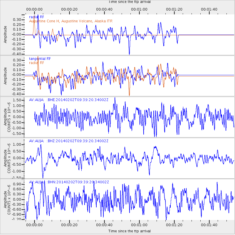
AUJA Augustine Cone H, Augustine Volcano, Alaska - Earthquake Result Viewer
*The percent match for this event was below the threshold and hence no stack was calculated.
| Earthquake location: |
South Of Kermadec Islands |
| Earthquake latitude/longitude: |
-32.9/-177.9 |
| Earthquake time(UTC): |
2014/02/02 (033) 09:26:37 GMT |
| Earthquake Depth: |
44 km |
| Earthquake Magnitude: |
6.5 MWW, 6.5 MWC, 6.5 MI |
| Earthquake Catalog/Contributor: |
NEIC PDE/NEIC COMCAT |
|
| Network: |
AV Alaska Volcano Observatory |
| Station: |
AUJA Augustine Cone H, Augustine Volcano, Alaska |
| Lat/Lon: |
59.34 N/153.42 W |
| Elevation: |
376 m |
|
| Distance: |
94.1 deg |
| Az: |
12.283 deg |
| Baz: |
200.437 deg |
| Ray Param: |
$rayparam |
*The percent match for this event was below the threshold and hence was not used in the summary stack. |
|
| Radial Match: |
47.859863 % |
| Radial Bump: |
400 |
| Transverse Match: |
53.104496 % |
| Transverse Bump: |
400 |
| SOD ConfigId: |
626651 |
| Insert Time: |
2014-04-20 14:08:11.215 +0000 |
| GWidth: |
2.5 |
| Max Bumps: |
400 |
| Tol: |
0.001 |
|
Signal To Noise
| Channel | StoN | STA | LTA |
| AV:AUJA: :BHZ:20140202T09:39:20.34002Z | 2.4947014 | 5.428192E-7 | 2.1758886E-7 |
| AV:AUJA: :BHN:20140202T09:39:20.34002Z | 1.0931357 | 6.590248E-7 | 6.028755E-7 |
| AV:AUJA: :BHE:20140202T09:39:20.34002Z | 0.8414244 | 3.9813088E-7 | 4.7316297E-7 |
| Arrivals |
| Ps | |
| PpPs | |
| PsPs/PpSs | |


