You are here: Home > Network List > II - Global Seismograph Network (GSN - IRIS/IDA) Stations List
> Station KIV Kislovodsk, Russia > Earthquake Result Viewer
KIV Kislovodsk, Russia - Earthquake Result Viewer
| Earthquake location: |
Myanmar |
| Earthquake latitude/longitude: |
19.3/95.0 |
| Earthquake time(UTC): |
1996/11/11 (316) 09:22:27 GMT |
| Earthquake Depth: |
80 km |
| Earthquake Magnitude: |
5.6 MB, 5.4 MS, 6.0 UNKNOWN, 5.9 MW |
| Earthquake Catalog/Contributor: |
WHDF/NEIC |
|
| Network: |
II Global Seismograph Network (GSN - IRIS/IDA) |
| Station: |
KIV Kislovodsk, Russia |
| Lat/Lon: |
43.96 N/42.69 E |
| Elevation: |
1054 m |
|
| Distance: |
49.9 deg |
| Az: |
311.623 deg |
| Baz: |
102.197 deg |
| Ray Param: |
0.068178244 |
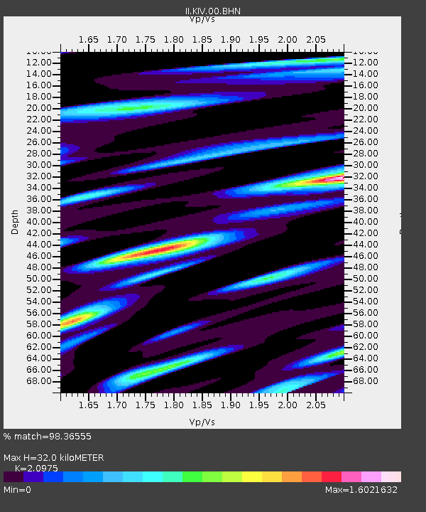
| Estimated Moho Depth: |
32.0 km |
| Estimated Crust Vp/Vs: |
2.10 |
| Assumed Crust Vp: |
6.247 km/s |
| Estimated Crust Vs: |
2.978 km/s |
| Estimated Crust Poisson's Ratio: |
0.35 |
|
| Radial Match: |
98.36555 % |
| Radial Bump: |
349 |
| Transverse Match: |
93.072525 % |
| Transverse Bump: |
400 |
| SOD ConfigId: |
6273 |
| Insert Time: |
2010-03-01 18:35:39.961 +0000 |
| GWidth: |
2.5 |
| Max Bumps: |
400 |
| Tol: |
0.001 |
|
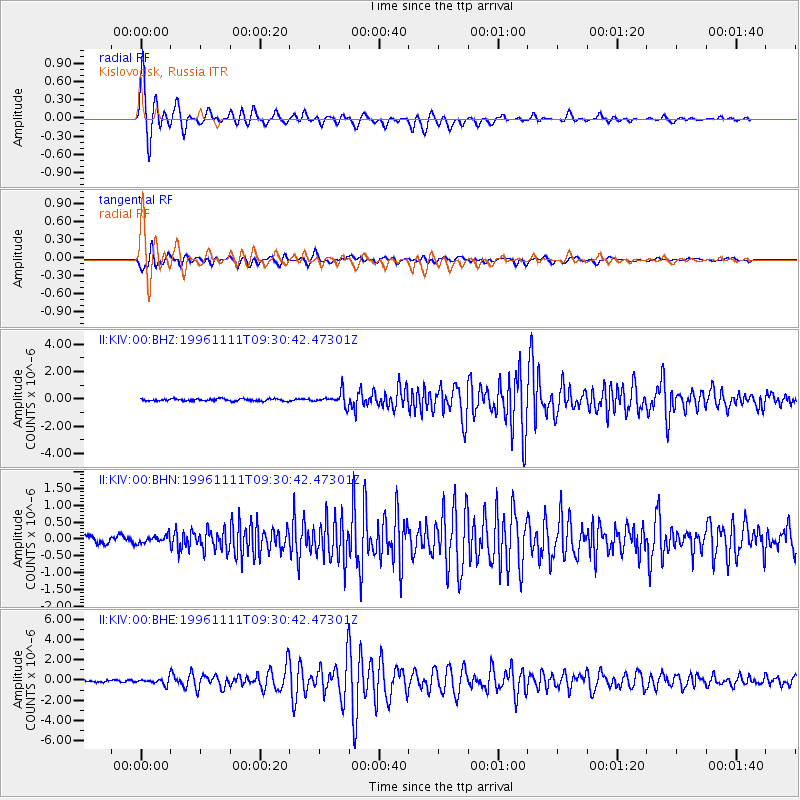
Signal To Noise
| Channel | StoN | STA | LTA |
| II:KIV:00:BHN:19961111T09:30:42.47301Z | 1.2122464 | 1.0845929E-7 | 8.946967E-8 |
| II:KIV:00:BHE:19961111T09:30:42.47301Z | 3.3861542 | 3.037832E-7 | 8.971334E-8 |
| II:KIV:00:BHZ:19961111T09:30:42.47301Z | 6.1727014 | 4.848821E-7 | 7.855267E-8 |
| Arrivals |
| Ps | 5.9 SECOND |
| PpPs | 15 SECOND |
| PsPs/PpSs | 21 SECOND |


