You are here: Home > Network List > AZ - ANZA Regional Network Stations List
> Station MONP2 Monument Peak TA Vault, Mt. Laguna, CA, USA > Earthquake Result Viewer
MONP2 Monument Peak TA Vault, Mt. Laguna, CA, USA - Earthquake Result Viewer
| Earthquake location: |
South Of Kermadec Islands |
| Earthquake latitude/longitude: |
-32.9/-177.9 |
| Earthquake time(UTC): |
2014/02/02 (033) 09:26:37 GMT |
| Earthquake Depth: |
44 km |
| Earthquake Magnitude: |
6.5 MWW, 6.5 MWC, 6.5 MI |
| Earthquake Catalog/Contributor: |
NEIC PDE/NEIC COMCAT |
|
| Network: |
AZ ANZA Regional Network |
| Station: |
MONP2 Monument Peak TA Vault, Mt. Laguna, CA, USA |
| Lat/Lon: |
32.89 N/116.42 W |
| Elevation: |
1000 m |
|
| Distance: |
87.4 deg |
| Az: |
47.721 deg |
| Baz: |
227.71 deg |
| Ray Param: |
0.04330773 |
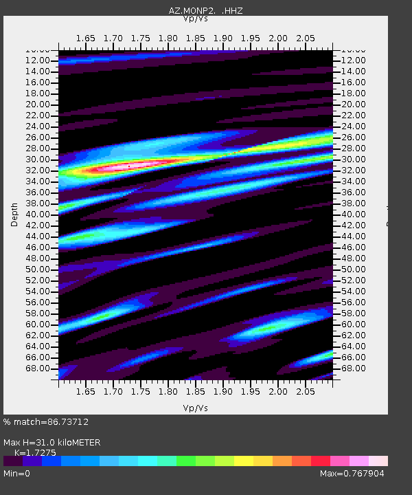
| Estimated Moho Depth: |
31.0 km |
| Estimated Crust Vp/Vs: |
1.73 |
| Assumed Crust Vp: |
6.264 km/s |
| Estimated Crust Vs: |
3.626 km/s |
| Estimated Crust Poisson's Ratio: |
0.25 |
|
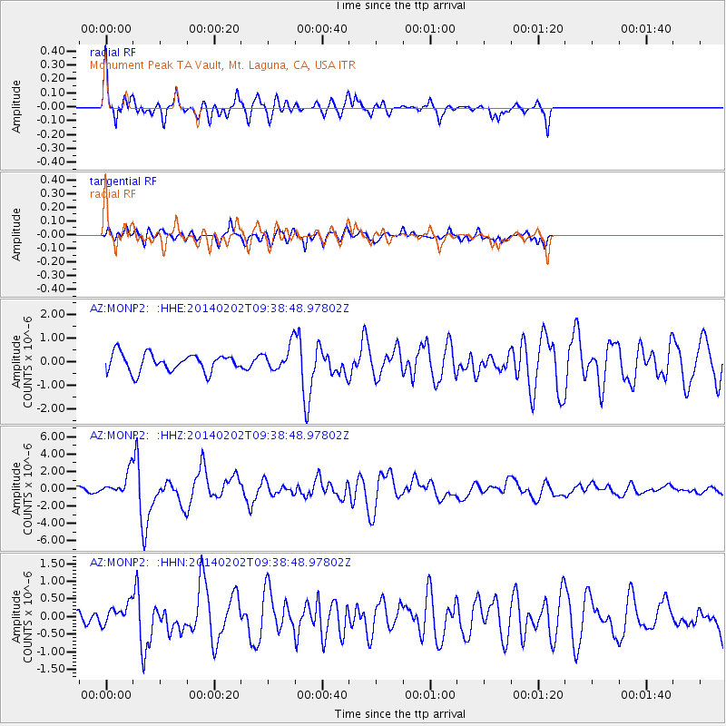
| Radial Match: |
86.73712 % |
| Radial Bump: |
367 |
| Transverse Match: |
74.996765 % |
| Transverse Bump: |
400 |
| SOD ConfigId: |
626651 |
| Insert Time: |
2014-04-20 14:08:54.758 +0000 |
| GWidth: |
2.5 |
| Max Bumps: |
400 |
| Tol: |
0.001 |
|
Signal To Noise
| Channel | StoN | STA | LTA |
| AZ:MONP2: :HHZ:20140202T09:38:48.97802Z | 3.3055634 | 1.3320662E-6 | 4.0297704E-7 |
| AZ:MONP2: :HHN:20140202T09:38:48.97802Z | 1.1095742 | 2.8883025E-7 | 2.603073E-7 |
| AZ:MONP2: :HHE:20140202T09:38:48.97802Z | 1.3546237 | 5.142325E-7 | 3.7961283E-7 |
| Arrivals |
| Ps | 3.7 SECOND |
| PpPs | 13 SECOND |
| PsPs/PpSs | 17 SECOND |


