You are here: Home > Network List > CB - China National Seismic Network Stations List
> Station HEH Heihe,Heilongjiang Province > Earthquake Result Viewer
HEH Heihe,Heilongjiang Province - Earthquake Result Viewer
| Earthquake location: |
Mindanao, Philippines |
| Earthquake latitude/longitude: |
8.6/121.5 |
| Earthquake time(UTC): |
2014/12/29 (363) 09:29:41 GMT |
| Earthquake Depth: |
38 km |
| Earthquake Magnitude: |
6.1 MWP |
| Earthquake Catalog/Contributor: |
NEIC PDE/NEIC COMCAT |
|
| Network: |
CB China National Seismic Network |
| Station: |
HEH Heihe,Heilongjiang Province |
| Lat/Lon: |
50.25 N/127.41 E |
| Elevation: |
165 m |
|
| Distance: |
41.8 deg |
| Az: |
5.686 deg |
| Baz: |
188.78 deg |
| Ray Param: |
0.07346972 |
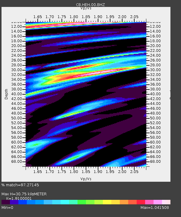
| Estimated Moho Depth: |
30.75 km |
| Estimated Crust Vp/Vs: |
1.91 |
| Assumed Crust Vp: |
6.419 km/s |
| Estimated Crust Vs: |
3.361 km/s |
| Estimated Crust Poisson's Ratio: |
0.31 |
|
| Radial Match: |
97.27145 % |
| Radial Bump: |
315 |
| Transverse Match: |
67.931946 % |
| Transverse Bump: |
400 |
| SOD ConfigId: |
3390531 |
| Insert Time: |
2019-04-15 20:15:53.122 +0000 |
| GWidth: |
2.5 |
| Max Bumps: |
400 |
| Tol: |
0.001 |
|

Signal To Noise
| Channel | StoN | STA | LTA |
| CB:HEH:00:BHZ:20141229T09:36:56.280009Z | 9.983643 | 1.1741429E-6 | 1.1760666E-7 |
| CB:HEH:00:BHN:20141229T09:36:56.280009Z | 8.438949 | 6.8034603E-7 | 8.061976E-8 |
| CB:HEH:00:BHE:20141229T09:36:56.280009Z | 2.0160694 | 1.2432794E-7 | 6.166847E-8 |
| Arrivals |
| Ps | 4.6 SECOND |
| PpPs | 13 SECOND |
| PsPs/PpSs | 18 SECOND |


