You are here: Home > Network List > IU - Global Seismograph Network (GSN - IRIS/USGS) Stations List
> Station JOHN Johnston Island, USA > Earthquake Result Viewer
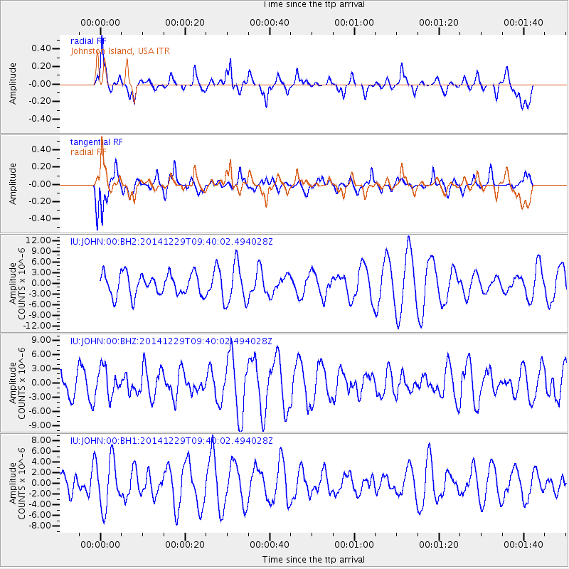
JOHN Johnston Island, USA - Earthquake Result Viewer
*The percent match for this event was below the threshold and hence no stack was calculated.
| Earthquake location: |
Mindanao, Philippines |
| Earthquake latitude/longitude: |
8.6/121.5 |
| Earthquake time(UTC): |
2014/12/29 (363) 09:29:41 GMT |
| Earthquake Depth: |
38 km |
| Earthquake Magnitude: |
6.1 MWP |
| Earthquake Catalog/Contributor: |
NEIC PDE/NEIC COMCAT |
|
| Network: |
IU Global Seismograph Network (GSN - IRIS/USGS) |
| Station: |
JOHN Johnston Island, USA |
| Lat/Lon: |
16.73 N/169.53 W |
| Elevation: |
2.0 m |
|
| Distance: |
67.5 deg |
| Az: |
75.466 deg |
| Baz: |
272.532 deg |
| Ray Param: |
$rayparam |
*The percent match for this event was below the threshold and hence was not used in the summary stack. |
|
| Radial Match: |
63.828186 % |
| Radial Bump: |
400 |
| Transverse Match: |
72.409805 % |
| Transverse Bump: |
400 |
| SOD ConfigId: |
3390531 |
| Insert Time: |
2019-04-15 20:16:31.260 +0000 |
| GWidth: |
2.5 |
| Max Bumps: |
400 |
| Tol: |
0.001 |
|
Signal To Noise
| Channel | StoN | STA | LTA |
| IU:JOHN:00:BHZ:20141229T09:40:02.494028Z | 1.0704263 | 2.8967133E-6 | 2.7061303E-6 |
| IU:JOHN:00:BH1:20141229T09:40:02.494028Z | 1.819197 | 4.5168526E-6 | 2.4828826E-6 |
| IU:JOHN:00:BH2:20141229T09:40:02.494028Z | 1.7903243 | 5.379428E-6 | 3.0047224E-6 |
| Arrivals |
| Ps | |
| PpPs | |
| PsPs/PpSs | |


