You are here: Home > Network List > IW - Intermountain West Stations List
> Station MOOW Moose Ponds, Wyoming, USA > Earthquake Result Viewer
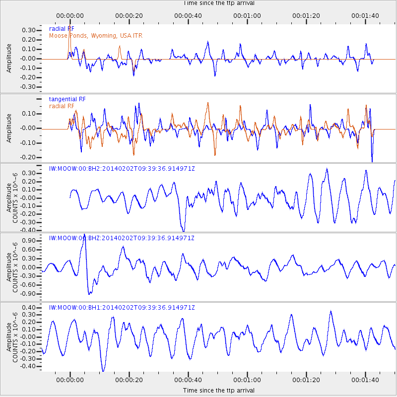
MOOW Moose Ponds, Wyoming, USA - Earthquake Result Viewer
*The percent match for this event was below the threshold and hence no stack was calculated.
| Earthquake location: |
South Of Kermadec Islands |
| Earthquake latitude/longitude: |
-32.9/-177.9 |
| Earthquake time(UTC): |
2014/02/02 (033) 09:26:37 GMT |
| Earthquake Depth: |
44 km |
| Earthquake Magnitude: |
6.5 MWW, 6.5 MWC, 6.5 MI |
| Earthquake Catalog/Contributor: |
NEIC PDE/NEIC COMCAT |
|
| Network: |
IW Intermountain West |
| Station: |
MOOW Moose Ponds, Wyoming, USA |
| Lat/Lon: |
43.75 N/110.74 W |
| Elevation: |
2128 m |
|
| Distance: |
97.8 deg |
| Az: |
42.376 deg |
| Baz: |
231.476 deg |
| Ray Param: |
$rayparam |
*The percent match for this event was below the threshold and hence was not used in the summary stack. |
|
| Radial Match: |
61.29937 % |
| Radial Bump: |
400 |
| Transverse Match: |
74.86763 % |
| Transverse Bump: |
400 |
| SOD ConfigId: |
626651 |
| Insert Time: |
2014-04-20 14:15:23.064 +0000 |
| GWidth: |
2.5 |
| Max Bumps: |
400 |
| Tol: |
0.001 |
|
Signal To Noise
| Channel | StoN | STA | LTA |
| IW:MOOW:00:BHZ:20140202T09:39:36.914971Z | 4.0652733 | 4.3945155E-7 | 1.08098895E-7 |
| IW:MOOW:00:BH1:20140202T09:39:36.914971Z | 0.9744887 | 1.3616504E-7 | 1.3972974E-7 |
| IW:MOOW:00:BH2:20140202T09:39:36.914971Z | 1.3333826 | 1.0725112E-7 | 8.043536E-8 |
| Arrivals |
| Ps | |
| PpPs | |
| PsPs/PpSs | |


