You are here: Home > Network List > XL12 - Hangay Dome, Mongolia Stations List
> Station HV21 HV21 > Earthquake Result Viewer
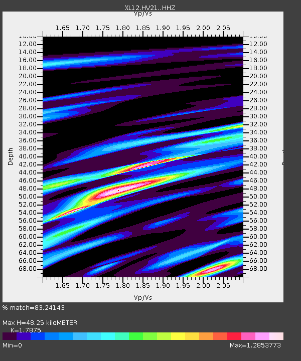
HV21 HV21 - Earthquake Result Viewer
| Earthquake location: |
Mindanao, Philippines |
| Earthquake latitude/longitude: |
8.6/121.5 |
| Earthquake time(UTC): |
2014/12/29 (363) 09:29:41 GMT |
| Earthquake Depth: |
38 km |
| Earthquake Magnitude: |
6.1 MWP |
| Earthquake Catalog/Contributor: |
NEIC PDE/NEIC COMCAT |
|
| Network: |
XL Hangay Dome, Mongolia |
| Station: |
HV21 HV21 |
| Lat/Lon: |
51.43 N/100.78 E |
| Elevation: |
1677 m |
|
| Distance: |
46.0 deg |
| Az: |
342.055 deg |
| Baz: |
150.879 deg |
| Ray Param: |
0.07084781 |
| Estimated Moho Depth: |
48.25 km |
| Estimated Crust Vp/Vs: |
1.79 |
| Assumed Crust Vp: |
6.419 km/s |
| Estimated Crust Vs: |
3.591 km/s |
| Estimated Crust Poisson's Ratio: |
0.27 |
|
| Radial Match: |
83.24143 % |
| Radial Bump: |
400 |
| Transverse Match: |
65.128494 % |
| Transverse Bump: |
400 |
| SOD ConfigId: |
3390531 |
| Insert Time: |
2019-04-15 20:17:52.544 +0000 |
| GWidth: |
2.5 |
| Max Bumps: |
400 |
| Tol: |
0.001 |
|

Signal To Noise
| Channel | StoN | STA | LTA |
| XL:HV21: :HHZ:20141229T09:37:29.819987Z | 28.517601 | 8.9156185E-7 | 3.1263564E-8 |
| XL:HV21: :HHN:20141229T09:37:29.819987Z | 12.669477 | 4.5667545E-7 | 3.604533E-8 |
| XL:HV21: :HHE:20141229T09:37:29.819987Z | 2.5137217 | 4.7067755E-7 | 1.872433E-7 |
| Arrivals |
| Ps | 6.3 SECOND |
| PpPs | 20 SECOND |
| PsPs/PpSs | 26 SECOND |


