You are here: Home > Network List > TA - USArray Transportable Network (new EarthScope stations) Stations List
> Station D04E Lakebay, WA, USA > Earthquake Result Viewer
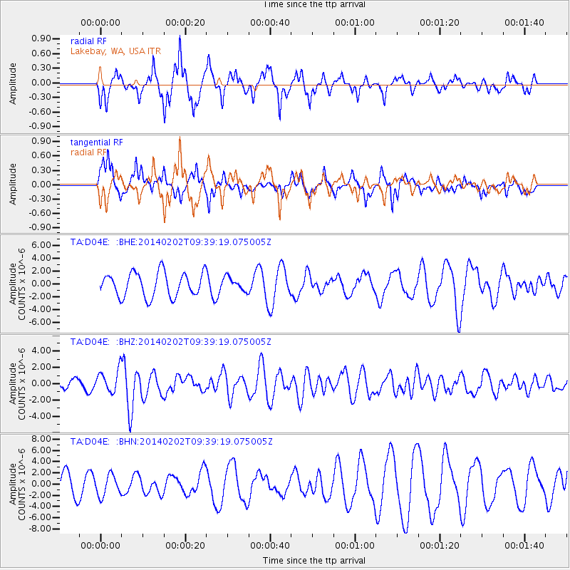
D04E Lakebay, WA, USA - Earthquake Result Viewer
*The percent match for this event was below the threshold and hence no stack was calculated.
| Earthquake location: |
South Of Kermadec Islands |
| Earthquake latitude/longitude: |
-32.9/-177.9 |
| Earthquake time(UTC): |
2014/02/02 (033) 09:26:37 GMT |
| Earthquake Depth: |
44 km |
| Earthquake Magnitude: |
6.5 MWW, 6.5 MWC, 6.5 MI |
| Earthquake Catalog/Contributor: |
NEIC PDE/NEIC COMCAT |
|
| Network: |
TA USArray Transportable Network (new EarthScope stations) |
| Station: |
D04E Lakebay, WA, USA |
| Lat/Lon: |
47.18 N/122.77 W |
| Elevation: |
45 m |
|
| Distance: |
93.8 deg |
| Az: |
34.112 deg |
| Baz: |
223.753 deg |
| Ray Param: |
$rayparam |
*The percent match for this event was below the threshold and hence was not used in the summary stack. |
|
| Radial Match: |
78.996826 % |
| Radial Bump: |
400 |
| Transverse Match: |
54.64186 % |
| Transverse Bump: |
353 |
| SOD ConfigId: |
626651 |
| Insert Time: |
2014-04-20 14:18:48.067 +0000 |
| GWidth: |
2.5 |
| Max Bumps: |
400 |
| Tol: |
0.001 |
|
Signal To Noise
| Channel | StoN | STA | LTA |
| TA:D04E: :BHZ:20140202T09:39:19.075005Z | 3.4317372 | 1.4561045E-6 | 4.243054E-7 |
| TA:D04E: :BHN:20140202T09:39:19.075005Z | 1.5107598 | 1.9099448E-6 | 1.264228E-6 |
| TA:D04E: :BHE:20140202T09:39:19.075005Z | 0.5609216 | 1.0480861E-6 | 1.8685073E-6 |
| Arrivals |
| Ps | |
| PpPs | |
| PsPs/PpSs | |


