You are here: Home > Network List > US - United States National Seismic Network Stations List
> Station AHID Auburn Hatchery, Idaho, USA > Earthquake Result Viewer
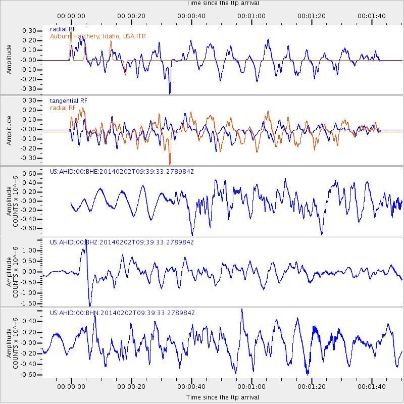
AHID Auburn Hatchery, Idaho, USA - Earthquake Result Viewer
*The percent match for this event was below the threshold and hence no stack was calculated.
| Earthquake location: |
South Of Kermadec Islands |
| Earthquake latitude/longitude: |
-32.9/-177.9 |
| Earthquake time(UTC): |
2014/02/02 (033) 09:26:37 GMT |
| Earthquake Depth: |
44 km |
| Earthquake Magnitude: |
6.5 MWW, 6.5 MWC, 6.5 MI |
| Earthquake Catalog/Contributor: |
NEIC PDE/NEIC COMCAT |
|
| Network: |
US United States National Seismic Network |
| Station: |
AHID Auburn Hatchery, Idaho, USA |
| Lat/Lon: |
42.77 N/111.10 W |
| Elevation: |
1960 m |
|
| Distance: |
97.0 deg |
| Az: |
42.986 deg |
| Baz: |
231.155 deg |
| Ray Param: |
$rayparam |
*The percent match for this event was below the threshold and hence was not used in the summary stack. |
|
| Radial Match: |
74.91318 % |
| Radial Bump: |
400 |
| Transverse Match: |
63.27872 % |
| Transverse Bump: |
400 |
| SOD ConfigId: |
626651 |
| Insert Time: |
2014-04-20 14:20:29.142 +0000 |
| GWidth: |
2.5 |
| Max Bumps: |
400 |
| Tol: |
0.001 |
|
Signal To Noise
| Channel | StoN | STA | LTA |
| US:AHID:00:BHZ:20140202T09:39:33.278984Z | 3.8116994 | 6.0875715E-7 | 1.5970754E-7 |
| US:AHID:00:BHN:20140202T09:39:33.278984Z | 1.1633652 | 1.6273407E-7 | 1.3988218E-7 |
| US:AHID:00:BHE:20140202T09:39:33.278984Z | 0.59993744 | 1.0227826E-7 | 1.7048154E-7 |
| Arrivals |
| Ps | |
| PpPs | |
| PsPs/PpSs | |


