You are here: Home > Network List > US - United States National Seismic Network Stations List
> Station ELK Elko, Nevada, USA > Earthquake Result Viewer
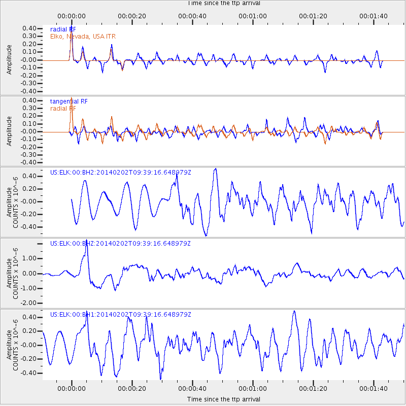
ELK Elko, Nevada, USA - Earthquake Result Viewer
*The percent match for this event was below the threshold and hence no stack was calculated.
| Earthquake location: |
South Of Kermadec Islands |
| Earthquake latitude/longitude: |
-32.9/-177.9 |
| Earthquake time(UTC): |
2014/02/02 (033) 09:26:37 GMT |
| Earthquake Depth: |
44 km |
| Earthquake Magnitude: |
6.5 MWW, 6.5 MWC, 6.5 MI |
| Earthquake Catalog/Contributor: |
NEIC PDE/NEIC COMCAT |
|
| Network: |
US United States National Seismic Network |
| Station: |
ELK Elko, Nevada, USA |
| Lat/Lon: |
40.74 N/115.24 W |
| Elevation: |
2210 m |
|
| Distance: |
93.3 deg |
| Az: |
42.527 deg |
| Baz: |
228.449 deg |
| Ray Param: |
$rayparam |
*The percent match for this event was below the threshold and hence was not used in the summary stack. |
|
| Radial Match: |
79.59559 % |
| Radial Bump: |
359 |
| Transverse Match: |
69.7641 % |
| Transverse Bump: |
400 |
| SOD ConfigId: |
626651 |
| Insert Time: |
2014-04-20 14:20:38.459 +0000 |
| GWidth: |
2.5 |
| Max Bumps: |
400 |
| Tol: |
0.001 |
|
Signal To Noise
| Channel | StoN | STA | LTA |
| US:ELK:00:BHZ:20140202T09:39:16.648979Z | 6.493386 | 7.499617E-7 | 1.1549624E-7 |
| US:ELK:00:BH1:20140202T09:39:16.648979Z | 1.2177981 | 2.2428675E-7 | 1.84174E-7 |
| US:ELK:00:BH2:20140202T09:39:16.648979Z | 0.8987706 | 1.8631025E-7 | 2.0729456E-7 |
| Arrivals |
| Ps | |
| PpPs | |
| PsPs/PpSs | |


