You are here: Home > Network List > US - United States National Seismic Network Stations List
> Station NLWA Neilton Lookout, Washington, USA > Earthquake Result Viewer
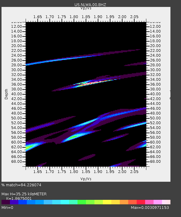
NLWA Neilton Lookout, Washington, USA - Earthquake Result Viewer
| Earthquake location: |
South Of Kermadec Islands |
| Earthquake latitude/longitude: |
-32.9/-177.9 |
| Earthquake time(UTC): |
2014/02/02 (033) 09:26:37 GMT |
| Earthquake Depth: |
44 km |
| Earthquake Magnitude: |
6.5 MWW, 6.5 MWC, 6.5 MI |
| Earthquake Catalog/Contributor: |
NEIC PDE/NEIC COMCAT |
|
| Network: |
US United States National Seismic Network |
| Station: |
NLWA Neilton Lookout, Washington, USA |
| Lat/Lon: |
47.39 N/123.87 W |
| Elevation: |
640 m |
|
| Distance: |
93.5 deg |
| Az: |
33.421 deg |
| Baz: |
222.993 deg |
| Ray Param: |
0.041232582 |
| Estimated Moho Depth: |
35.25 km |
| Estimated Crust Vp/Vs: |
1.87 |
| Assumed Crust Vp: |
6.566 km/s |
| Estimated Crust Vs: |
3.516 km/s |
| Estimated Crust Poisson's Ratio: |
0.30 |
|
| Radial Match: |
94.226074 % |
| Radial Bump: |
191 |
| Transverse Match: |
95.229576 % |
| Transverse Bump: |
203 |
| SOD ConfigId: |
626651 |
| Insert Time: |
2014-04-20 14:20:54.341 +0000 |
| GWidth: |
2.5 |
| Max Bumps: |
400 |
| Tol: |
0.001 |
|

Signal To Noise
| Channel | StoN | STA | LTA |
| US:NLWA:00:BHZ:20140202T09:39:17.450005Z | 1.9508052 | 2.2561898E-7 | 1.1565429E-7 |
| US:NLWA:00:BH1:20140202T09:39:17.450005Z | 2.5637162 | 4.858573E-9 | 1.8951292E-9 |
| US:NLWA:00:BH2:20140202T09:39:17.450005Z | 0.8026139 | 6.5107975E-10 | 8.1119916E-10 |
| Arrivals |
| Ps | 4.8 SECOND |
| PpPs | 15 SECOND |
| PsPs/PpSs | 20 SECOND |


