You are here: Home > Network List > UW - Pacific Northwest Regional Seismic Network Stations List
> Station LON Longmire (broad-band and DWWSSN) > Earthquake Result Viewer
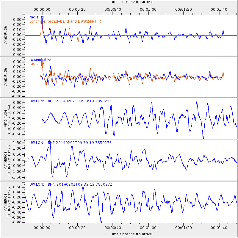
LON Longmire (broad-band and DWWSSN) - Earthquake Result Viewer
*The percent match for this event was below the threshold and hence no stack was calculated.
| Earthquake location: |
South Of Kermadec Islands |
| Earthquake latitude/longitude: |
-32.9/-177.9 |
| Earthquake time(UTC): |
2014/02/02 (033) 09:26:37 GMT |
| Earthquake Depth: |
44 km |
| Earthquake Magnitude: |
6.5 MWW, 6.5 MWC, 6.5 MI |
| Earthquake Catalog/Contributor: |
NEIC PDE/NEIC COMCAT |
|
| Network: |
UW Pacific Northwest Regional Seismic Network |
| Station: |
LON Longmire (broad-band and DWWSSN) |
| Lat/Lon: |
46.75 N/121.81 W |
| Elevation: |
850 m |
|
| Distance: |
94.0 deg |
| Az: |
34.885 deg |
| Baz: |
224.401 deg |
| Ray Param: |
$rayparam |
*The percent match for this event was below the threshold and hence was not used in the summary stack. |
|
| Radial Match: |
76.0046 % |
| Radial Bump: |
399 |
| Transverse Match: |
69.51019 % |
| Transverse Bump: |
400 |
| SOD ConfigId: |
626651 |
| Insert Time: |
2014-04-20 14:22:41.929 +0000 |
| GWidth: |
2.5 |
| Max Bumps: |
400 |
| Tol: |
0.001 |
|
Signal To Noise
| Channel | StoN | STA | LTA |
| UW:LON: :BHZ:20140202T09:39:19.785027Z | 5.888221 | 7.9375735E-7 | 1.3480428E-7 |
| UW:LON: :BHN:20140202T09:39:19.785027Z | 1.0549358 | 2.3003724E-7 | 2.1805805E-7 |
| UW:LON: :BHE:20140202T09:39:19.785027Z | 1.8231621 | 2.7850245E-7 | 1.5275792E-7 |
| Arrivals |
| Ps | |
| PpPs | |
| PsPs/PpSs | |


