You are here: Home > Network List > UW - Pacific Northwest Regional Seismic Network Stations List
> Station OMAK Colville Reservation, Omak, WA, USA > Earthquake Result Viewer
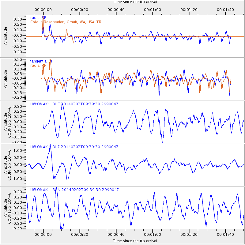
OMAK Colville Reservation, Omak, WA, USA - Earthquake Result Viewer
*The percent match for this event was below the threshold and hence no stack was calculated.
| Earthquake location: |
South Of Kermadec Islands |
| Earthquake latitude/longitude: |
-32.9/-177.9 |
| Earthquake time(UTC): |
2014/02/02 (033) 09:26:37 GMT |
| Earthquake Depth: |
44 km |
| Earthquake Magnitude: |
6.5 MWW, 6.5 MWC, 6.5 MI |
| Earthquake Catalog/Contributor: |
NEIC PDE/NEIC COMCAT |
|
| Network: |
UW Pacific Northwest Regional Seismic Network |
| Station: |
OMAK Colville Reservation, Omak, WA, USA |
| Lat/Lon: |
48.36 N/119.33 W |
| Elevation: |
696 m |
|
| Distance: |
96.3 deg |
| Az: |
34.921 deg |
| Baz: |
226.22 deg |
| Ray Param: |
$rayparam |
*The percent match for this event was below the threshold and hence was not used in the summary stack. |
|
| Radial Match: |
63.87666 % |
| Radial Bump: |
400 |
| Transverse Match: |
53.959415 % |
| Transverse Bump: |
379 |
| SOD ConfigId: |
626651 |
| Insert Time: |
2014-04-20 14:22:50.508 +0000 |
| GWidth: |
2.5 |
| Max Bumps: |
400 |
| Tol: |
0.001 |
|
Signal To Noise
| Channel | StoN | STA | LTA |
| UW:OMAK: :BHZ:20140202T09:39:30.299004Z | 3.8502207 | 6.7505516E-7 | 1.7532895E-7 |
| UW:OMAK: :BHN:20140202T09:39:30.299004Z | 1.1906204 | 1.7856831E-7 | 1.4997921E-7 |
| UW:OMAK: :BHE:20140202T09:39:30.299004Z | 0.8016967 | 1.2974719E-7 | 1.6184075E-7 |
| Arrivals |
| Ps | |
| PpPs | |
| PsPs/PpSs | |


