You are here: Home > Network List > YN10 - San Jacinto Fault Zone Stations List
> Station JF00 JF00 > Earthquake Result Viewer
JF00 JF00 - Earthquake Result Viewer
| Earthquake location: |
South Of Kermadec Islands |
| Earthquake latitude/longitude: |
-32.9/-177.9 |
| Earthquake time(UTC): |
2014/02/02 (033) 09:26:37 GMT |
| Earthquake Depth: |
44 km |
| Earthquake Magnitude: |
6.5 MWW, 6.5 MWC, 6.5 MI |
| Earthquake Catalog/Contributor: |
NEIC PDE/NEIC COMCAT |
|
| Network: |
YN San Jacinto Fault Zone |
| Station: |
JF00 JF00 |
| Lat/Lon: |
33.42 N/116.40 W |
| Elevation: |
646 m |
|
| Distance: |
87.7 deg |
| Az: |
47.34 deg |
| Baz: |
227.705 deg |
| Ray Param: |
0.043037362 |
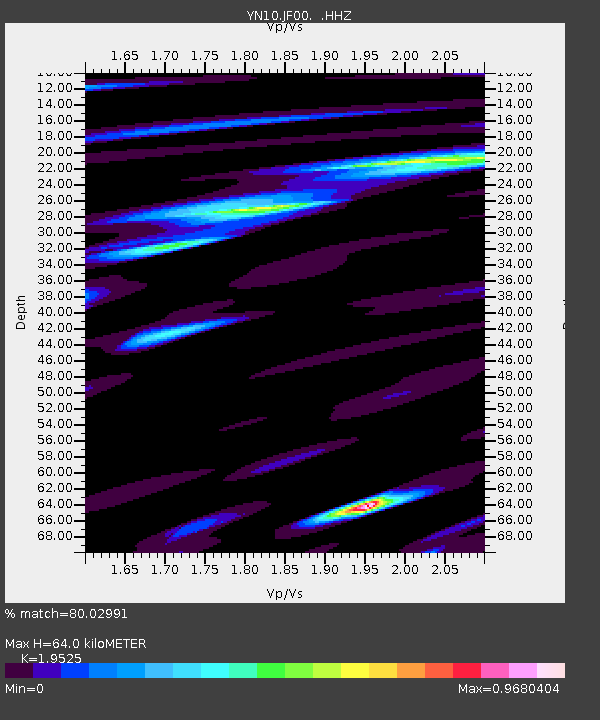
| Estimated Moho Depth: |
64.0 km |
| Estimated Crust Vp/Vs: |
1.95 |
| Assumed Crust Vp: |
6.264 km/s |
| Estimated Crust Vs: |
3.208 km/s |
| Estimated Crust Poisson's Ratio: |
0.32 |
|
| Radial Match: |
80.02991 % |
| Radial Bump: |
400 |
| Transverse Match: |
82.33252 % |
| Transverse Bump: |
400 |
| SOD ConfigId: |
626651 |
| Insert Time: |
2014-04-20 14:23:37.565 +0000 |
| GWidth: |
2.5 |
| Max Bumps: |
400 |
| Tol: |
0.001 |
|

Signal To Noise
| Channel | StoN | STA | LTA |
| YN:JF00: :HHZ:20140202T09:38:50.744011Z | 6.460625 | 1.4988017E-6 | 2.3199019E-7 |
| YN:JF00: :HHN:20140202T09:38:50.744011Z | 1.7263019 | 6.414181E-7 | 3.7155618E-7 |
| YN:JF00: :HHE:20140202T09:38:50.744011Z | 0.8341965 | 2.2541475E-7 | 2.702178E-7 |
| Arrivals |
| Ps | 9.9 SECOND |
| PpPs | 30 SECOND |
| PsPs/PpSs | 40 SECOND |


